Current season
|
Back to historical analysis main page
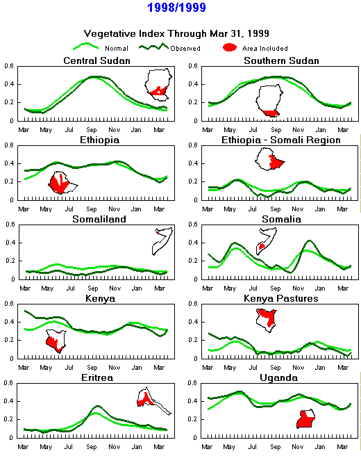
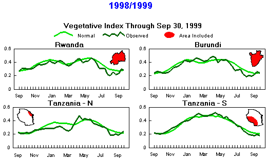
Seasonal Vegetation Index
(Note differences in months due to timing of seasons)
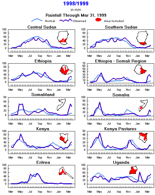
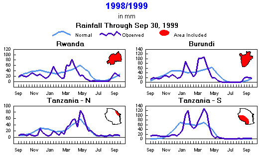
Seasonal Rainfall
(Note differences in months due to timing of seasons)
Current season
|
Back to historical analysis main page
Preliminary Monthly Weather Analysis
Eastern Africa and the Horn
From the African Desk, Climate Prediction Center, NOAA
Note: This information should be used with caution.
Weather data based on preliminary reports.
-
September 1999 - Satellite rainfall estimates showed monthly rainfalls over 300 mm along the border region between Sudan and Ethiopia. Elsewhere, monthly totals were below normal except over central Sudan and some isolated cases in northern Sudan, northern Ethiopia, western Kenya, and Rwanda. Near normal temperatures prevailed. >
- September 21-30 1999 - Satellite rainfall estimates showed heavy rains (100-200 mm) over the central border region of Ethiopia with Sudan. Elsewhere, rainfall was below normal except over central and northern Ethiopia and northern Sudan. There were isolated occurrences of above-normal rainfall in northern Sudan. Above-normal temperatures were observed over northern Sudan (2-3 degrees C above normal), while near-normal temperatures prevailed over most parts of the region.
-
September 11-20 1999 - Dry conditions prevailed across the region, except central Sudan and parts of central Ethiopia, where rainfall amounts totaled 30-90 mm (90-380% of normal). Unseasonable rains (15-40 mm; 95-170% of normal) were observed along the coast of Kenya, while lighter rains fell in southern Kenya. Satellite rainfall estimates indicated dry conditions over Somalia, while heavy rains (50-200 mm) were estimated over the northern part of Republic Democratic of Congo. Temperatures were generally 2 to 4 degrees C above normal in Sudan and below normal (3-5 degrees C ) were observed over much of Kenya, Uganda, Rwanda, Burundi, and Tanzania.
-
September 1-10 1999 - Dry conditions prevailed over much of the region. However, heavy rains (48-104 mm; 127-206% of normal) persisted over northern Ethiopia and extended into east-central Sudan. Rainfall over southwestern Ethiopia continued below normal (1-25 mm; 1-50% of normal). Four-week amounts totaled under 50% of normal there. The dryness extended into southeastern Sudan. Seasonably dry weather prevailed across southeastern Ethiopia and the pastoral areas of Kenya. A few showers dampened Somalias coast, while the interior was seasonably dry. Temperatures were near normal.
-
August 1999 - The rainfall pattern was mixed, with monthly rainfall below normal in southwest Ethiopia and above normal in central Sudan, northern Ethiopia and the border region between Sudan and Ethiopia. Amounts exceeded 300 mm in northern Ethiopia and 100 mm in central Sudan. Somalias totals were generally above normal due to anomalous showers in early August. Monthly temperatures were near normal, except 2-3 degrees C below normal over western Tanzania.
-
August 21-31 1999 - Heavy downpours (112-153 mm; 139-296% of normal) continued over northern Ethiopia and extended into east-central Sudan. Lighter rains fell south and north of this region, with below-normal rains in Sudans Blue and Upper Nile regions and southwestern Ethiopia. Rains were also below normal in southeastern parts of North Darfur and adjacent areas of Kordofan in central Sudan, but heavy rains fell across this region during the preceding period. Temperatures were near normal across the region.
-
August 11-20 1999 - Isolated heavy downpours (70-150 mm; 140-270 % of normal) soaked east-central Sudan eastward into northern Ethiopia. Lighter rains were observed across much of the region. Satellite rainfall estimates indicated seasonably dry conditions over Somalia, Tanzania, and the Lake Victoria basin. Temperatures were near normal across the region, except over western Tanzania, where readings were 2 to 5 degrees C below normal.
-
August 1-10 1999 - Isolated heavy rains (41-159 mm; 126-488% of normal) fell over central Sudan, while heavy showers overspread central Ethiopia (102-136 mm). Unseasonably heavy showers (35-105 mm; 400-800% of normal) fell near Lake Victoria in western Kenya and northern Tanzania. Temperatures were near normal except for isolated values in western Kenya and western Tanzania of 2 to 4 degrees C below normal.
-
July 1999 - The main rainy season started around early July in the areas of north-central Ethiopia that had experienced severe drought during the belg season. The current season has produced seasonably heavy rains across western and northern parts of the country. Southern and eastern areas were seasonably dry. Rainfall in Sudan was variable. Most of the main crop areas tallied 100 mm or more for the month, but the satellite estimates suggested that dry pockets developed, and somewhat higher-than-normal temperatures were consistent with below-normal rain in parts of central Sudan. In Kenyas crop areas near Lake Victoria, amounts were adequate, but surrounding areas were drier than normal. Rainfall was close to seasonal levels elsewhere in East Africa.
-
July 21-31 1999 - Seasonably heavy rains (50-200 mm; 70-110% of normal) fell over crop areas in Eritrea and Ethiopia, while heavy showers overspread Sudans crop areas (50-100 mm, isolated 150 mm). The remainder of East Africa was seasonably dry except for showers (25-50 mm) in western Kenya and western Uganda. Parts of Ethiopia, Uganda, and Kenya and southern Sudan remained below normal. Temperatures averaged 1 to 4 degrees C below normal in Tanzania and near normal elsewhere.
-
July 11-20 1999 - Heavy rains (50-105 mm; 135-350% of normal) fell in northern Ethiopia, adjacent southern Eritrea, and southern Sudan, while drier conditions prevailed over central Sudan and southwestern Ethiopia. Unseasonably heavy rains (50-100 mm; 115-280 % of normal) fell over most of Uganda and parts of extreme western Kenya, while seasonable dryness continued over extreme southwest Uganda, most of Kenya, and Tanzania, except for isolated wet spots on the coast. Meteosat rainfall estimates indicated seasonably dry conditions over Somalia, Rwanda, and Burundi. Temperatures were generally 1 to 2 degrees C below normal.
-
July 1-10 1999 - Heavy rains finally covered north central Ethiopia with amounts ranging from 45 to 195 mm (180-230% of normal). The rains, which likely marked the start of the rainy season in northern Ethiopia, extended to eastern and central Sudan, where spotty rains (10-60 mm; 70-150 % of normal) were observed. Seasonable dryness prevailed to the east part of Ethiopia into Somalia, though. Unseasonable rains (5-60 mm) fell over Kenya, while dryness prevailed over much of Uganda, Tanzania, Burundi, and Rwanda. Meteosat rainfall estimates indicated dry conditions over Somalia. Temperatures were generally 2 to 4 degrees C below normal across much of the region. They were 1 to 2 degrees C above normal over Sudan.
-
June 1999 - Below normal rains fell over parts of Kenya, southwestern Uganda, and much of Ethiopia. Abundant rains fell in southwestern Kenya, central Ethiopia, and southwestern Sudan. Temperatures averaged 1 to 4 degrees C below normal over Tanzania. Readings were near normal elsewhere, except over western Sudan, where they averaged 1 to 2 degrees C above normal.
-
June 21-30 1999 - Abundant rains (90-110 mm; 80-255% of normal) fell over southeast Sudan and central Ethiopia. In drought-afflicted areas in north-central Ethiopia (Wello and Shewa provinces), rainfall was abnormally light (0-10 mm; 0-50% of normal), indicating a slow start to the main rainy season. Eastern Ethiopia was seasonably dry. Drier conditions prevailed over Kenya, Uganda, Tanzania, and eastern Ethiopia. Meteosat rainfall estimates indicated dryness over Somalia, Eritrea, Rwanda, and Burundi, but little rainfall is expected during this time of the year in these countries. Temperatures averaged generally 1 to 3 degrees C below normal across Tanzania, Uganda, and southern Sudan. They were near to above normal over the northern half of Sudan, Ethiopia, and Kenya.
-
June 11-20 1999 - Rainfall was light (0-2 mm; 0-15% of normal) in north-central Ethiopia, where the earlier failure of the first rains caused drought. Rains typically increase around this time of year as the second rainy season gets underway. Heavier rains (30-100 mm) fell over western Ethiopia, but the south and east were seasonably dry. Parts of the south and east also recorded below-normal rains during the first season. Rainfall was minimal in Kenya, even in the west. Erratic rains this season have left some pastoral areas in the north and crop areas in the southwest with drought. Similarly, a poor rainy season affected Rwanda and southwest Uganda earlier. During June 11-20, rains were light over southwest Uganda and negligible over Rwanda. Somalia, which had a shortened rainy season, remained seasonably dry this period, but the rains in Sudan failed to progress northward, leaving central areas abnormally dry as well as parts of the south. Temperatures 2 to 3 degrees C above normal aggravated dryness in central Sudan. Readings were near normal elsewhere in East Africa.
-
June 1-10 1999 - Seasonably dry weather continued in drought-affected north-central Ethiopia, but moderate to heavy rains (10-50 mm) fell over western Ethiopia. Drier-than-normal weather continued in southern and eastern Ethiopia, Somalia, and the pastoral areas of Kenya, as well as Rwanda and southwestern Uganda. Estimated rainfall during the past 4 weeks has been under 50% of normal for most of this region. Satellite estimates again indicated dry weather for Somalia, where the rainy season was abnormally short. Satellite data indicated heavy showers over southern Sudan, especially in the southwest, with lighter rains in central Sudan. Temperatures over East Africa were near normal, except 1 to 3 degrees C above normal in central Sudan and 2 to 4 degrees C below normal in northern Tanzania.
-
May 1999 - The monthly highlight for May was the confirmed failure of the short season (belg) rains in north-central Ethiopia. The monthly rainfall was light to negligible (0-20 mm; 0-40% of normal) from Wello province southward through N. Shewa. As May is typically the last month of the belg rains, the season ended as badly as it began. Showers were heavy (200-300 mm or more; 100-150% of normal) in western Ethiopia, but rainfall was also below normal in the south and east, including the Ogaden region, where rainfall amounts ranged from 0 to 50 mm; (0-60% of normal). In addition, the rainy season ended early in Somalia, with little rain over most of the crop regions in southern and central Somalia after May 10. Monthly totals were mainly in the 20 to 50 mm range, compared with a normal of 20 to 100 mm. The rainy season also appeared to end early in Burundi, Rwanda, southwestern Uganda, and parts of Kenya, especially in northern pastoral areas and the south-central and southeastern areas of Kenya away from the oceans coast (0-50 mm; 0-30% of normal). Monthly totals in Burundi, Rwanda, and southwest Uganda were mostly under 25% of normal. Rainfall was normal to above normal in central and southwestern Sudan, with amounts exceeding 300 mm locally in southwestern Sudan, according to satellite estimates.
-
May 21-31 1999 - Heavy rain (50-130 mm) fell across the western third of Ethiopia, but the drought-affected area of north-central Ethiopia picked up little or no rain. Rainfall was abnormally light in southern and eastern Ethiopia, with amounts mostly under 10 mm except for isolated totals exceeding 30 mm. Eritrea, where the rainy season normally starts toward the end of June, was seasonably dry. The rainy season appears to have ended early in Somalia, where the southern half of the country recorded little or no rain. The main season rains started somewhat late, so the length of the season has been significantly shortened, essentially lasting from mid-April to early May. Rainfall was abnormally light (0-35 mm; 0-75% of normal) in southwestern Kenya and along the northern border with Ethiopia, a sign that the main rainy season may be ending early in Kenya. The season also ended early in Burundi and Rwanda, where little or no rain fell again. Seasonably heavy rains (25-100 mm) fell over Uganda and southwestern Sudan, according to satellite estimates. In contrast, rainfall was spotty in southwestern Sudan, where estimated amounts diminished from the previous period. Temperatures were generally near normal across the region, except 2 to 4 degrees C below normal in southwestern Sudan and 2 to 3 degrees C above normal in northern Sudan.
-
May 11-20 1999 - Little or no rain (0-12 mm) fell from Eritrea southward through central Ethiopia into Kenya, allowing the drought in north-central Ethiopia to continue unabated. The first (belg) rainy season has failed across Wello and Shewa provinces, and rainfall has been below normal over most of the remaining belg crop areas in Ethiopia. In addition, most of the Ogaden has been dry this month. Rainfall diminished across southern Somalia, where satellite estimates indicated 0 to 25 mm amounts. This contrasts with normal amounts of 20 to 30 mm. Northern Somalia (north of the sixth parallel) totaled above-normal amounts of 25 to 100 mm, except for lower amounts near the north coast. Except in the far eastern and western coastal areas, rainfall was abnormally light in Kenya (0-12 mm; 0-30% of normal). Rainfall in southern Kenya has totaled less than 50% of normal during the past 4 weeks. Little or no rain occurred over Rwanda, Burundi, western Tanzania, and southwestern Uganda. The rainy season ended early in this region. Ample rains (25-100 mm) fell over the rest of Uganda. Satellite estimates indicated widespread, heavy showers (50-150 mm) across southern Sudan from the 10th parallel southward. Temperatures were generally 1 to 2 degrees C below normal across East Africa.
-
May 1-10 1999 - Rainfall totaled only 0 to 10 mm over north-central Ethiopia, including Tigray, Wello, and Shewa provinces. This contrasts with normal rainfall of 10 to 25 mm. The first (belg) rainy season has been a virtual failure in this area, with near-normal rains only falling during parts of March. The rains in north-central Ethiopia often taper off toward late May, so the likelihood of consequential rainfall during this season is diminishing. Moderate to heavy showers (25-110 mm) fell over western parts of Ethiopia, while moderate rains (10-55 mm) fell in the south and extended into central Kenya as well as southern Somalia. Most of the main Kenyan crop areas again recorded seasonable showers, though dry pockets persisted, especially from Nairobi southward to the Tanzanian border. Heavy rain (50-110 mm; 100-150% of normal) covered eastern Tanzania, but most of the western half of the country remained dry. The rainy season appears to have ended somewhat early in western Tanzania, as the rains stopped in mid-April. Heavy showers (50-150 mm) stretched across southern Sudan and moved northward into east-central Sudans sorghum areas, where significant rainfall this early in the season is unusual. Satellite estimates indicated that heavy showers (50-150 mm) also fell over Uganda. Temperatures were generally 1 to 2 degrees C below normal across East Africa.
-
April 1999 - Worsening drought in central and northern Ethiopia highlighted the month, though late-month rains eased dryness elsewhere in Ethiopia. The entire belg rainy season has been poor in Ethiopia, especially in north-central areas (Shewa and Wello Provinces). April rainfall totaled less than 25% of normal in central and north-central Ethiopia and less than 50% of normal in the east. Late-month rains brought monthly totals up to 100% of normal in much of the west, but localized areas measured less than 50% of normal. Rainfall over the northern half of Kenya and adjacent southern Ethiopia totaled 50 to 60% of normal, so the season continued rather poor in the pastoral areas of Kenya. It was a mixed picture in the main crop areas of Kenya, as parts of the Rift Valley recorded under 50% of normal rainfall, while some stations farther west near Lake Victoria reported over 100% of normal and more than 200 mm. Satellite estimates suggest that April was abnormally dry in Rwanda and southwest Uganda. Rainfall was also likely below normal in Burundi and western Tanzania. Estimated amounts, however, exceeded 150 mm in eastern Tanzania and in the northwest near Lake Victoria.
-
April 21-30 1999 - Moderate to heavy showers (25-100 mm) covered the western, southern, and eastern third of Ethiopia. However, rainfall remained below normal (0-25 mm) in central and northern sections, continuing the drought that has prevailed since February. Somalia saw widespread showers this period, according to satellite imagery, with only the escaping the rains. Showers were also frequent across southern Sudan, with satellite-estimated rainfall of 50 to 150 mm in Equatoria, Jonglei, and southern parts of Lakes and Bahr El Ghazal. Dry weather encompassed western Tanzania, Rwanda, Burundi, southern Uganda, and parts of southwest Kenya. This was the second consecutive period that rainfall was below normal in western Tanzania and southwest Kenya. Satellite-estimated rainfall was above normal (50-150 mm) in northern Uganda, including the more-arid northeast region. Temperatures were generally 1 to 3 degrees C below normal in Tanzania, Uganda, and southwest Ethiopia, and near normal elsewhere.
-
April 11-20 1999 - Severe dryness continued across northern and western Ethiopia, with scattered showers providing little drought relief. Significant rainfall was limited to southwestern and south-central parts of the country, which measured 0 to 100 mm (0-145% of normal). The belg rainy season has been a virtual failure from the 10th parallel northward in Ethiopia as well as western Ethiopia north of the 8th parallel. This area collected mostly 10 mm or less during April 11-20 as well as April 1-10. Since February, the only period of seasonable rain occurred in early March. Conditions have also been dry in far eastern Ethiopia and Somalia north of the 5th parallel, but seasonable showers (25-100 mm) relieved dryness over southern Somalia this period. In Sudan, seasonable showers fell over the far south (Equatoria), but little rain has fallen so far this season in southern Sudan just north of Equatoria (Bahr El Ghazal, Lakes, Jonglei). Temperatures were generally above-normal (1-3 degrees C) in the dry areas of Sudan, Ethiopia, and Somalia, worsening the situation. In Kenya, rainfall was somewhat below normal, but 50 to 100 mm of rain relieved dryness in the northeast. Pockets of dryness occurred in the northwest and in the Rift Valley in west-central Kenya. Below-normal rains fell across interior Tanzania (0-25 mm; 0-60% of normal), with heavier rains (25-50 mm) near the coast. Season-to-date rainfall remains near to above normal in Tanzania due to heavy rains in March. Satellite rainfall estimates suggested that rains were seasonable in the Lakes region (Rwanda, Burundi, Uganda, Malawi, 0- 50 mm). Temperatures in this area averaged 1 to 3 degrees below normal.
-
April 1-10 1999 - Dryness further intensified across northern and
western Ethiopia, as significant rainfall was limited to the extreme southwest of the country. Amounts of 0 to 6 mm were under 25% of normal and represented a continuation of the dryness that has affected northern and many western sections since February. Dryness has been especially severe north of the 10th parallel this season, affecting Wello and Shewa provinces, but dryness has also affected the west down to the 8th parallel. Above-normal temperatures worsened dryness in northern Ethiopia, where readings averaged 2 to 4 degrees C above normal. Sparse rainfall reports indicated near to above-normal rains in extreme southern Sudan, suggesting the rainy season may have begun. In Somalia, only a few showers fell in the southwest, with the remainder of the country dry. As the main rainy usually starts in early April, it is now somewhat delayed. In Kenya, rainfall was generally above normal in the southwest, including most of the main maize region, but northern and eastern areas recorded less than 25% of normal rainfall. Four-week rainfall totals were below 25% of normal at some locations in the north and east, but over twice normal in the southwest. Above-normal rains also fell across Tanzania (25-90 mm; 50-280% of normal), continuing the wet pattern prevailing since February. Satellite rainfall estimates suggested that rains diminished over Rwanda and Burundi, with estimated amounts ranging from around 25 to 100 mm in Burundi and 10 to 30 mm in Rwanda. In Uganda, moderate to heavy rains (50-150 mm) covered central and northern parts, with lighter amounts (under 25 mm) in the southwest.
-
March 1999 - Parts of the region recorded substantial rains, particularly in eastern Tanzania, the western half of Kenya, and eastern Ethiopia, where rainfall amounts were 85-340% of normal. Drier conditions prevailed over the western part of Ethiopia, Rwanda, the eastern part of Kenya, central and western Tanzania, and Uganda. Satellite rainfall estimates indicated that dry conditions prevailed over Somalia, while southern Sudan estimated rainfall ranged between 20 and 50 mm.
-
March 21-31 1999 - Northern crop areas of Ethiopia remained dry until showers fell on March 27. Given that normal rains this season have been limited to the first 10 days of March, drought has developed north of the 10th parallel. Showers were more numerous in southern and central areas of the country, where rainfall totals were 120 to 180% of normal at some locations. However, rainfall was nearly non-existent across western Ethiopia, where most stations recorded little or no rain, resulting in near-drought conditions west of the 38th meridian. The extreme southern Sudan was also drier than normal, though showers in the south at the end of March gave hope that the rainy season was beginning. The rainy season typically starts around late March or early April in the south. Despite some promising showers in Somalia during mid-March, showers were sparse during the latter part of the month, indicating that the rainy season was not yet established. The season usually starts in early April across southern Somalia. Rainfall was below-normal over the eastern half of Kenya. In the western half , however, rainfall totals of 20 to 130 mm (70-220% of normal) kept moisture conditions intact. Heavy showers (60-220 mm; 200-270% of normal) pounded parts of central and southern Tanzania. Satellite rainfall estimates suggested that moderate rains (25-100 mm) fell over Uganda, Rwanda, and Burundi.
-
March 11-20 1999 - Rainfall (50-100 mm) was above normal south and east of Addis in Ethiopia, but below normal to the north, where amounts were negligible. Because February rainfall was below normal, this area, which includes Wello and North Shewa provinces, is vulnerable to drought if the rains do not improve shortly. In contrast, above-normal rains (5-100 mm) fell in southern Somalia and northern Kenya. If the rains represent the start of the rainy season in Somalia, they are early, as the rains typically start around the beginning of April. Amounts (25-60 mm) in western and central Kenya and northern Tanzania were seasonable, but rainfall has been unusually heavy since late February in western Tanzania and eastern DR Congo, where amounts this period ranged from 100 to 200 mm, according to satellite estimates. Widespread showers (50-100 mm) continued to increase moisture levels in Uganda, Rwanda, and Burundi. Satellite estimates indicated a few showers over southern Sudan, where the rainy season has not yet become established. Temperatures were generally 1 to 3 degrees C below normal across the region.
-
March 1-10 1999 - The belg rains (15-80 mm) began in central Ethiopia at the start of March, following abnormal dryness in February. Moderate rains (10-100 mm) appeared to mark the start of the main rainy season in central and western Kenya, helping to relieve drought. While little rain (0-10 mm) fell over northern and eastern areas, the minimal moisture was not unseasonable. Above-normal rains (100-200 mm) stretched from western Tanzania through DR Congo and northern Angola. The ample moisture extended northward through Burundi and into Rwanda (50-150 mm), relieving dryness in Rwanda. Widespread moderate (40-100 mm) rains also eased dryness in Uganda, though the extreme northeast remained rainless. Satellite estimates indicated a few showers over Somalia, where the rainy season usually starts in the first week of April, and southern Sudan, where widespread rains have started between mid-March and mid-April in recent years. Temperatures were generally near normal across the region, though 2 to 4 degrees C below normal in Uganda. After months of above-normal temperatures, readings in central and northern Sudan averaged close to normal.
-
February 1999 - Rainfall declined from January levels, with below-normal rainfall in Ethiopia, Kenya, Uganda, and Rwanda. Amounts were mainly under 10 mm in Kenya and Ethiopia and in the 0 to 50 mm range in Rwanda and Uganda. Normal February rainfall is generally 20 to 70 mm, except for 90 to 150 mm in Rwanda. The dryness continued Kenyas drought, but heavier rains relieved drought over much of Tanzania, with only the far northern interior remaining abnormally dry. Tanzanias long rains (masika) typically start in February. Ethiopias short rains (belg) usually start in February, and these have been delayed. Rwandas second season rains are normally underway in February, so the observed dryness was unusual and represented a significant delay in the rainy season. Monthly temperatures were near normal except in Sudan, where readings were much above normal in central and northern areas, exceeding the normal by 3 to 5 degrees C.
-
February 21-28 1999 - Dryness intensified across northern areas, including Ethiopia and Kenya, though widespread showers eased dryness in Tanzania. Little or no rain (0-5 mm) fell in Ethiopia and Kenya, with showers mainly limited to western Ethiopia and near Kenyas Lake Victoria. The dryness aggravated the long-term drought in Kenya. In Ethiopia, the short rainy season (belg rains) has been significantly delayed. Seasonable showers (10-70 mm) eased the drought in parts of northern Tanzania, but dryness continued near the Kenyan border. Beneficial showers (25-50 mm) eased dry conditions in Uganda, but satellite imagery indicated that rainfall continued light and below normal in Rwanda. Sudan and Somalia were seasonably dry except in the extreme south of Sudan, where satellite imagery indicated some showers. Satellite rainfall estimates indicated moderate to heavy rains (10-200 mm) over DR Congo. Temperatures were generally near normal except in Sudan and northwestern Ethiopia, where readings ranged from 2 to 7 degrees C above normal.
-
February 11-20 1999 - Rainfall was negligible and below normal from southwestern Kenya and southern Uganda south through Burundi and northern Tanzania, maintaining long-term drought in interior Kenya, northern Tanzania, southern Uganda, and Rwanda. Pockets of light to moderate rains (5-30 mm; 10-80% of normal) brought slight relief to central and southeastern Kenya. Variable rainfalls (0-50 mm) were somewhat below normal over central and southern Tanzania. Little or no rain fell over Ethiopia. The first rainy season (belg rains) is somewhat delayed, though the dryness is not yet critical. Sudan and Somalia were seasonably dry. Satellite rainfall estimates indicated moderate to heavy rains (10-200 mm) over DR Congo and slight rains (less than 10 mm) over Rwanda and Burundi. Temperatures were generally near normal except in Sudan, where readings ranged from 1 to 6 degrees C above normal.
-
February 1-10 1999 - Most countries remained dry except for an isolated pocket of light rains (less than 10 mm) over south Tanzania. As a result, the long-term drought continued in Kenya and adjacent areas of Tanzania. The lack of rain in Ethiopia was not unusual for early February, but the belg rains usually start by mid-February and a delay into March would be a cause for concern. Conditions were seasonably dry in Somalia. Satellite rainfall estimates indicated moderate to isolated heavy rains (10-200 mm) over DR Congo and moderate rains (10 to 50 mm) over Rwanda and Burundi. Temperatures were generally near normal except in Sudan, where readings ranged from 1 to 4 degrees C above normal.
-
January 1999 - Heavy rains relieved drought in central and southern Tanzania during January, and brought limited relief to the north. Totals ranged from near 10 mm in the far north of Tanzania to 400 mm in the southwest. Abundant rains (75-200 mm) fell over southern Uganda, Rwanda, Burundi, and near Lake Victoria in Kenya. However, rainfall was again below normal (0-25mm, 0-50%) elsewhere in Kenya, as the drought continued. Seasonably dry weather prevailed in Somalia. Amounts of 5 to 80 mm were 200 to 450% of the monthly normal in western and northern Ethiopia.
-
January 21-31 1999 - Rains tapered off from the heavy levels recorded during January 11-20 over Tanzania. However, amounts in Tanzania ranging from 50 mm in central areas to over 150 mm in the southwest continued to reduce the deficits that accumulated during October-December. Little or no rain fell in Kenya and northern Tanzania during this period, allowing drought to continue. Normal rainfall is light at this time of year, typically ranging from 10 to 20 mm. With La Niña expected to continue during the next few months, rainfall should tend to remain below normal in Kenya and northern Tanzania through March, when the long rains usually start. To the north, Ethiopia and Somalia were dry. The belg rains normally begin by late February in Ethiopia, and the main season rains start in early April over Somalia. Temperatures were generally near normal.
-
January 11-20 1999 - The heaviest rains in 12 months spread across Tanzania, significantly relieving drought. Moderate to heavy rains (50-200 mm) fell over most of the country, with only extreme northern and eastern areas measuring light to moderate amounts (0-50 mm). Moderate rains (10-90 mm; 15-300% of normal) fell over western Ethiopia and the Lake Victoria region, including adjacent parts of Tanzania, Uganda, and Kenya. Amounts over southern Uganda and elsewhere around Lake Victoria were unseasonably high, the 10-day totals equivalent to typical monthly amounts. Seasonably dry weather (0-10 mm) prevailed over the rest of Kenya, Uganda, Ethiopia, and Somalia. Satellite rainfall estimates indicated moderate to isolated very heavy rains (10 to more than 200 mm) over DR Congo and moderate to heavy rains (10-200 mm) over Burundi and south Rwanda. Temperatures were generally near normal.
-
January 1-10 1999 - Most countries reported below-normal rains except for an isolated pocket of unseasonable light to moderate rains (1-55 mm; 1 to 30 mm above normal) over eastern Sudan and northern Ethiopia. Moderate rains (10-50 mm; 40-100% of normal) fell over Lake Victoria and adjacent parts of Kenya, Tanzania, and Uganda, offering some dryness relief. Light rains (less than 10 mm) fell over much of Kenya and north-central and southeastern Tanzania, maintaining the drought that has persisted since October. Based on past La Niña rainfall patterns, dryness in Kenya and northern Tanzania should continue into March. Satellite rainfall estimates indicated moderate to isolated very heavy rains (10 to more than 200 mm) over DR Congo and 10 to 25 mm over Rwanda and Burundi. Temperatures were generally near normal except in central Sudan, where they averaged 1 to 3 degrees C above normal.
-
December 1998 - Much of the region recorded below-normal rainfall during December. Light to moderate rains (2-50 mm; 10-80% of normal) fell over western and southeastern Tanzania and eastern Kenya. Satellite rainfall estimates depicted moderate to heavy rains (50-300 mm) over DR Congo and light to moderate rains (20-50 mm) over Burundi and Rwanda. Less than 20 mm fell over western Kenya, Uganda, and central and northeast Tanzania. The northern (bimodal) areas of Tanzania experienced a poor short rains season, while the southern areas experienced a poor start to their main rainy season, as drought had enveloped the eastern two-thirds of the country at the end of the month. October-December rainfall totaled just 2 to 60% of normal over most of Tanzania and 2 to 70% of normal across Kenya. Temperatures averaged near to slightly below normal across the region except over Sudan, where readings averaged 1 to 3 degrees C above normal.
-
December 21-31 1998 - Drought continued in much of Tanzania, as most countries reported below-normal rains except for moderate rains (40-75 mm; 50-110% of normal) over western Tanzania (including Shinyanga and Tabora provinces) and light rains (less than 10 mm) over central and southeastern Kenya and eastern Tanzania. Less than 70 mm of rain has fallen on Kenya and Tanzania since the beginning
of December, resulting in precipitation deficits of 50 to 155 mm. The short rainy season in the bimodal areas of northern Tanzania typically ends in December, so significant drought-ending rains are not likely there until the long rainy season gets underway in March. Satellite rainfall estimates indicated moderate to isolated heavy rains (10-200 mm) over DR Congo and 0 to 25 mm over Rwanda, Burundi, and Uganda. Temperatures were generally near normal except in Sudan, where readings averaged 1 to 4 degrees C above normal.
-
December 11-20 1998 - Drought has developed over much of Tanzania and parts of Kenya. Most countries in the region reported below-normal rains except for an isolated pocket of moderate rains (10-20 mm; 15-85% of normal) over southeastern Kenya and light rain (less than 10 mm) over southern Ethiopia. Light to moderate rains (2-45 mm; 20-90% of normal) fell over Lake Victoria and adjacent parts of Tanzania and Kenya. The rains in northwest Tanzania eased drought around Shinyanga. Cumulative rainfall since late October in most of Tanzania ranges from 10 to 50% of normal. Satellite estimates show rainfall has been below normal in Uganda since mid-November. Satellite rainfall estimates indicated moderate to isolated heavy rains (10-150 mm) over DR Congo and slight to moderate rainfall (2-25 mm) over Rwanda, Burundi, and coastal Somalia. Temperatures were generally near normal except in Sudan, where readings averaged 1 to 3 degrees C above normal.
-
December 1-10 1998 - Most countries reported below-normal rains except for an isolated pocket of moderate rains (10-50 mm; 20-175% of normal) over eastern Kenya. Dry conditions intensified over interior Tanzania, where rainfall totaled 0 to 25 mm (0-25% of normal). Moderate rains (25-70 mm; 25-210% of normal) fell over the southern coast of Tanzania, but rainfall diminished in the previously wet northern coast of Tanzania and the southern coast of Kenya. Rainfall deficits characteristic of the cold episode (La Niña) continued to affect Tanzania and parts of Kenya. Cumulative totals for the past 4 weeks have been under 50% of normal from western and southern Kenya southward through most of Tanzania. During La Niñas, parts of East Africa, including northern Tanzania and western Kenya, tend to be abnormally dry from November through March. In Ethiopia and southern Sudan, the seasonal rains withdrew. Satellite rainfall estimates indicated slight to moderate--but somewhat below normal--rains over Uganda, Rwanda, and Burundi, seasonably light rains over Somalia, and moderate to isolated heavy rains (10-150 mm) over DR Congo. Temperatures were generally near normal except in Sudan, where readings were generally 2 to 4 degrees C above normal.
-
November 1998 - The rains retreated southward seasonally in November, but much of the area recorded below-normal rainfall. Satellite estimates indicated that light to moderate rains (10-90 mm) fell over southern Sudan. In Ethiopia, the light rains (10-40 mm) in the south were below normal. In Kenya and Uganda, rains tended to diminish during the month and, by the end of the month, most of the area was recording below-normal rainfall. In Tanzania, the seasonal rains were delayed, resulting in well below-normal amounts in all but the east, which recorded significant rain late in the month. Satellite estimates suggest November rainfall was below normal in Rwanda and somewhat below normal in Burundi. Temperatures averaged near to slightly below normal across the region except over Sudan, where readings averaged 1 to 3 degrees C above normal in central areas.
-
November 21-30 1998 - A general decrease in precipitation from the previous 10-day period occurred, suggesting a gradual withdrawal of seasonal rains from southern parts of Ethiopia and Sudan. Moderate to heavy rains (40-130 mm; 50-260% of normal) fell along the coastline from Tanzania to southern Kenya. Light to moderate rains (10-40 mm; 30-70% of normal) fell over south-central Kenya. The northern and western parts of Kenya reported little or no rain (less than 11 mm). Light rains reduced deficits over northeastern Tanzania, but western areas remained abnormally dry. Four-week rainfall totals have been under 25% of normal in parts of southern Kenya and western Tanzania. Satellite rainfall estimates indicated moderate to isolated heavy rains (25-150 mm) over DR Congo. Burundi and Rwanda collected normal to below-normal amounts. In southern Somalia, estimated rainfall (1-25 mm) was slightly below normal. Temperatures averaged 1 to 3 degrees C below normal, but 1 to 4 degrees C above normal in Sudan.
-
November 11-20 1998 - Rainfall amounts were light to moderate, except for an isolated 135 mm over central Kenya. Between 10 and 45 mm (25-145% of normal) of precipitation fell over southern Ethiopia, southern Sudan, Uganda, eastern and western Kenya, and along the coastline of Kenya extending to the northern coast of Tanzania. Little or no rain fell over northeastern Tanzania, indicating the prevalence of drier-than-normal conditions. Four-week rainfall amounts there are less than 25% of normal. Meteosat-based rainfall estimates indicated moderate to isolated heavy rains (25-150 mm) over DR Congo. Satellite estimates depicted light to moderate rainfall over Rwanda, Burundi, and Somalia. Temperatures were generally near normal.
-
November 1-10 1998 - Rainfall declined over Ethiopia and southern Sudan, where amounts totaled less than 35 mm, in contrast to the above-normal amounts reported earlier. Moderate rains (25-75mm; 30-330% of normal) fell over Kenya and Uganda. Eastern Kenya also reported moderate rains, reducing deficits experienced since the start of the rainy season. Precipitation shortfalls, however, continued to accumulate over northeastern Tanzania. Meteosat-based rainfall estimates indicated moderate to heavy rains (25-200 mm) over DR Congo. Satellite estimates depicted light to moderate rainfall over Rwanda, Burundi, and southern Somalia, including the previously-dry area in extreme southern Somalia. Near-normal to below-normal temperatures dominated the region except over Sudan, where 2 to 4 degree C positive departures were reported.
-
October 1998 - Rainfall was above normal over western Ethiopia and southeastern Sudan, causing localized flooding. Moderate to heavy rainfall (60-200 mm) covered western Ethiopia, eastern Sudan, western Kenya, and much of Uganda. Light to moderate rains (20-60 mm) fell over central Uganda, the Kenyan coast, and the northern coastline of Tanzania. Satellite rainfall estimates depicted moderate to heavy rainfall (100-300 mm) over DR Congo, but lighter amounts over Burundi and Rwanda. Elsewhere, normal to drier-than-normal conditions prevailed in Somalia and eastern Ethiopia. Temperatures averaged near normal to 1 to 3 degrees C below normal over Uganda and northern Tanzania.
-
October 21-31 1998 - Above normal rainfall (30-70 mm; 60-290% of normal) continued to affect southern Sudan and southwestern Ethiopia. Satellite estimates indicated somewhat below-normal rains (10-25 mm) over central Somalia and dry weather over the interior in the extreme south (Lower Juba, Gedo). Meteosat estimates depicted moderate rainfall (25-100 mm) over DR Congo, Uganda, Burundi, Rwanda, and northwestern Tanzania. Moderate rains (30-65 mm; 60-130% of normal) fell over western Kenya. Eastern Kenya and northeastern Tanzania continued to experience rainfall deficits, with some locations reporting virtually no rain, increasing the likelihood of drought this season. Dryness can be associated with La Niña episodes in this part of Africa. Temperatures were generally 1 to 3 degrees C cooler than normal over most of East Africa.
-
October 11-20 1998 - A slight decline in rainfall occurred in Ethiopia, in contrast to excessive rains which had been reported since July. Moderate rains (30-65 mm; 135-390% of normal) fell over western Ethiopia, southern Uganda, western Kenya, and along the northern coastline of Tanzania. In Sudan, unseasonably wet weather lingered over central and southern areas, with estimated rainfall amounts of 25 to 100 mm over most crop areas. Meteosat estimates also depicted moderate to heavy rainfall (25-100 mm) over DR Congo, northern Uganda, and Rwanda. Persistent dryness, however, continued over northern Tanzania and eastern Kenya, enhancing the likelihood of below normal rainfall associated with the La Niña episode. Temperatures averaged 1 to 4 degrees C lower than normal over most of East Africa.
-
October 1-10 1998 - Moderate to heavy rainfall (60-120 mm; 180-735% of normal) pounded central Ethiopia and southeastern Sudan. Rainfall has tended to be excessive in Ethiopia since July, and has recently increased in amount and spatial coverage, causing flash floods in various parts of the country. Light to moderate rains (10-80 mm; 50-280% of normal) fell over western Kenya and southern Uganda. Satellite rainfall estimates indicated moderate rains (25-100 mm) over DR Congo and Uganda. The rest of the region reported less than 20 mm of rainfall. Temperatures averaged 1 to 4 degrees C lower than normal over most countries but near normal over northeastern Kenya and Ethiopia.
-
September 1998 - Moderate to heavy rains (50-255 mm) covered central Ethiopia and extended to southern Eritrea and eastern and central Sudan. Eastern Uganda and the western Kenya highlands continued to receive moderate rainfall (40-140 mm; 40-160% of normal). Elsewhere, less than 40 mm were recorded. Meteosat estimates indicated a pocket of heavy rainfall (150-300 mm) over northwestern Ethiopia and adjacent border areas of Sudan. Temperatures were near normal over most countries except northern Tanzania, where -1 to -3 degree C departures were reported.
-
September 21-30 1998 - Heavy rains (90-120 mm; 120-200% of normal) resumed over western Ethiopia. A notable reduction in rainfall occurred over western Sudan. Moderate rains (20-60 mm; 60-320% of normal) fell over eastern Sudan, eastern Ethiopia, western Kenya, and extreme northern Tanzania. The rest of the region reported fewer than 20 mm of rainfall. Satellite imagery indicated an easing of rains over Sudan with moderate falls (25-100 mm) restricted to southwestern and southeastern border areas. Estimates also indicated moderate amounts (25-100 mm) over southeastern Eritrea. In general, totals diminished over previously wet areas of Rwanda, Uganda, and Kenya, estimates ranging from 20 to 50 mm. Temperature departures of -1 to -3 degrees C covered most countries with the exception of Sudan, where temperatures averaged 1 to 3 degrees C above normal.
-
September 11-20 1998 - In East Africa, moderate to heavy rains (30-140 mm; 100-560% of normal ) fell over western Ethiopia and western Sudan (Darfur). Satellite imagery continued to indicate moderate rainfall over southwest Sudan, with the moisture spreading into southeastern Sudan during this period. Estimates indicated rainfall easing (less than 100 mm) over the border area of Eritrea, Ethiopia, and Sudan. Amounts diminished across
western Ethiopia and eastern Sudan, lessening the flood threat along the Blue Nile in Sudan. The rest of the region remained seasonably dry except for Uganda and Rwanda, where estimated amounts ranged from 25 to 50 mm. Temperatures ranged from 1 to 3 degrees C below normal over eastern Ethiopia and northern Tanzania. Above normal temperatures covered eastern Sudan and western Kenya.
-
September 1-10 1998 - Rainfall diminished in Sudan and Ethiopia. Western and eastern parts of central Sudan registered moderate rainfall (25-75 mm; 80-300% of normal), but Kordofan saw lower amounts (0-40 mm). Satellite imagery depicted amounts ranging from 25 to 100 mm over southwest Sudan. Estimates indicated heavy rainfall (120 mm plus) over the border area of Eritrea, Ethiopia, and Sudan. Estimated rainfall was seasonable over the remainder of Ethiopia and Eritrea, as well as Kenya and Uganda. The rest of the region remained seasonably dry except for some locations around Lake Victoria in southern Uganda and northern Tanzania. Temperatures ranged from 2 to 4 degrees C below normal over northern Ethiopia to near normal elsewhere in East Africa.
-
August 1998 - Light to moderate rains (30-140 mm; 30-196% of normal) fell over eastern Uganda and the western Kenya highlands. Meteosat estimates indicated moderate to heavy rains (150-300 mm) across central and northwest Ethiopia and Eritrea. In Sudan, while the month started somewhat dry, crop areas were recording plentiful rains by late August. Elsewhere, less than 30 mm were reported. Temperatures were near normal but 2 to 4 degrees C below normal over much of Tanzania.
-
August 21-31, 1998 - For the third consecutive 10-day period, moderate to heavy rains continued to douse border areas of east Sudan and central and western parts of Ethiopia and its southern highlands. Rainfall amounts ranged from 50 to 120 mm (50-300% of normal). Abundant rains continued over Eritrea. Also, unseasonably heavy rains (40-70 mm) fell in Djibouti, according to satellite imagery. The Ogaden in Ethiopia also observed above-normal rains (15-40 mm). Light to moderate rainfall continued to prevail over western Kenya and most of Uganda (5-60 mm) while the rest of East Africa remained seasonably dry. Satellite imagery depicted amounts ranging from 50 to 125 mm over southwest Sudan, including adjacent border areas of D. R. Congo and Central African Republic. Widespread rains covered Sudan's crop areas. Temperatures ranged from 2 to 4 degrees C above normal over northern Sudan to near normal over the rest of East Africa except in eastern Ethiopia and central and southern Tanzania, where they averaged 2 to 4 degrees C below normal.
-
August 11-20, 1998 - Moderate to heavy rainfall continued to pound border areas of east Sudan and central and western parts of Ethiopia, spreading to the southern highlands. Amounts ranged from 60 to180 mm (50-200% of normal). In Sudan, while station data show spotty dryness in Darfur, Kordofan, and the southwest, some satellite imagery suggests normal to above-normal rainfall over these areas. Otherwise, satellite data indicate abnormally heavy rains (25-100 mm) in southeastern Sudan. The season has been below normal in central Sudan, characterized by a slow start to the rainy season and persistent high temperatures. In Eritrea, heavy rains (40-120 mm) fell in the southwest. Over western Kenya and most of Uganda, rainfall was light to moderate (10-50 mm). The remaining areas of East Africa were seasonably dry. Temperatures averaged 2 to 3 degrees C above normal in northern Sudan and 2 to 3 degrees C below normal over Uganda and western Kenya.
-
August 1-10, 1998 - Central and western parts of Ethiopia and border areas of Sudan continued to feature moderate to heavy rainfall (50-120 mm; 80-250% of normal). High-elevation areas of Ethiopia reported very heavy rainfall, in excess of 170 mm. Southeastern Sudan received below-normal rainfall (5-40 mm; 10-70% of normal). Western Kenya and eastern Uganda measured light rainfall, in the range of 10 to 25 mm. Remaining areas of East Africa were seasonably dry. Temperatures were 2 to 3 degrees C above normal in northern crop areas of western Sudan and near normal elsewhere. However, from the desert areas of Sudan northward to Egypt, extreme heat prevailed, with temperatures averaging 3 to 5 degrees C above normal.
-
July 1998 - Northeastern Ethiopia measured mostly above-normal rains (60-420 mm; 80-140% of normal). Over southern Sudan, amounts of 50 to 240 mm were seasonable. In central Sudan, most crop areas ended up with near-normal rainfall totals for the month, though some dry pockets persisted in Darfur and Kordofan and other areas endured excessive rains. Western Kenya and central Uganda amounts ranged from 20 to 180 mm (20-120% of normal). Temperatures were near normal except in Tanzania, where readings were 2 to 3 degrees C below normal.
-
July 21-31, 1998 - Significant amounts of rain continued to fall over eastern Eritrea, central and northeastern Ethiopia, and adjacent border areas of Sudan, where amounts varied from 60 to 210 mm (50-300% of normal). Elsewhere, rainfall over much of southern Sudan remained seasonable, according to satellite estimates, ranging from under 25 mm near Uganda's border to 100 mm farther north. Heavy rains hit some central areas of Sudan, causing flooding in Darfur, with amounts up to 165 mm in the eastern sorghum areas. Rainfall was light to moderate over western Kenya and Uganda (3-30 mm). Temperatures were near normal over Kenya and Uganda, but 3 to 5 degrees C below normal over much of Tanzania.
-
July 11-20, 1998 - The bulk of central and northeastern Ethiopia and central and southern Sudan measured significant amounts of rainfall (60-180 mm; 80-200% of normal). The rains in Sudan eased dry conditions, but cumulative amounts in central areas from Darfur to Kassala remain below normal. In addition, high temperatures continued to increase evaporation across central Sudan. Moderate to heavy rains, ranging from 40 to 120 mm, fell over western Kenya and Uganda. Temperatures over much of Sudan and northeastern Ethiopia ranged from 2 to 3 degrees C above normal, but were near normal over the rest of East Africa.
-
July 1-10, 1998 - Rains improved significantly across central Sudan, with 10 to 60 mm widespread from Kordofan east to Kassala. Nevertheless, amounts were variable, and some locations, especially in the west (Darfur), recorded under 10 mm. Also, temperatures remained unusually high, averaging 2 to 3 degrees C above normal across central areas, maintaining high evaporation rates. More consistent rains are needed to eliminate the deficits that have accumulated since May. In southern Sudan, where rainfall appeared to be the most widespread since late May, satellite estimates indicated moderate to heavy rains (25-100 mm). Heavy rains (50-125 mm) covering crop areas in Ethiopia and Eritrea likely signaled the start to the main rainy season in this region. Light to moderate rains fell in western Kenya (10-50 mm), while satellite estimates indicated below-normal amounts (0-10 mm) for the second consecutive 10-day period in northern and central Uganda.
-
June 1998 - Variable but mostly above-normal rains (30-400 mm; 80-500% of normal) fell in central and western Ethiopia as well as the central and coastal areas of Kenya. Sudan continued to accumulate rainfall deficits, featuring light rains (2-69 mm; 5-40% of normal) in the cental and eastern areas. Southern Sudan fared better, and some areas in the south received moderate to heavy amounts (40-200 mm). Temperatures averaged 2 degrees C above normal over Sudan and near normal elsewhere.
-
June 21-30, 1998 - Hot weather intensified dryness across central Sudan, where no significant rain fell north of the 12th parallel. Rainfall has been abnormally low since May in central Sudan, with dry conditions covering agricultural areas of Northern Darfur, Northern Kordofan, White Nile, Blue Nile, El Gezira, and Kassala. Showers dropped 2 to 20 mm of rain (5-40% of normal) farther south, near the 10th parallel, and totals ranged from 10 to 50 mm across southern Sudan. Heavy rains (50-100 mm) fell near the border with the Central African Republic. Widespread rains are needed soon to avoid drought across central Sudan. Most other parts of East Africa recorded normal to above-normal rains. Moderate to heavy rains (50-180 mm; 90-260% of normal) fell in western and southwestern Ethiopia. Little or no rain fell over eastern Ethiopia and Somaliland, an area that has seen little moisture since late May. Most areas of Kenya (including the seasonably dry north) experienced moderate rainfall (20-170 mm; 65-600% of normal). The near equatorial trough over the Indian Ocean enhanced rainfall along the eastern African coast from northern Tanzania to Somalia, where rainfall ranged between 25 and 170 mm. The rains relieved dryness in Somalia, which had been experiencing a shortfall since May. Interior eastern Kenya and Tanzania, as well as Uganda, Rwanda, and Burundi, remained seasonably dry. Temperatures averaged 2 to 4 degrees C above normal in central and eastern Sudan while western Uganda was 3 degrees C below normal.
-
June 11-20, 1998 - Rains brought some relief from recent heat and dryness to central Sudan, advancing north of the 11th parallel into the mechanized sorghum areas in the east and the traditional crop areas to the west in Darfur and Kordofan, but amounts (1-50 mm) tended to be below normal while temperatures remained high. Rainfall has been below normal across central Sudan since mid-May. Moderate to heavy rains (90-205 mm; 125-165% of normal) fell over southwestern Ethiopia, while central and southern areas of Ethiopia, southeastern Sudan, western Kenya, and southeastern Uganda measured light to moderate amounts (25-100 mm; 70-120% of normal). Satellite imagery depicted heavy thunderstorms originating from the Ethiopian highlands advancing westward across southern Sudan on June 15 and 16. Seasonably dry weather persisted over much of Somalia, coastal and northeastern Kenya, Tanzania, Rwanda, and Burundi. Showers fell in southern Somalia from the equator southward, while rainfall remained negligible over Somaliland, northeastern Ethiopia, and pastoral areas of eastern Ethiopia for the 4th week. Temperatures averaged 2 to 3 degrees C above normal in central and northern Sudan, while Tanzania experienced lower-than-normal temperatures (-2- to -4-degree C departures).
-
June 1-10, 1998 - Light to moderate rains (15-90 mm; 70 ->200% of normal) covered southwestern Ethiopia, central and western Kenya, and southern Sudan. Satellite imagery indicated heavy thunderstorms advancing westward across southern Sudan on June 4. In contrast, rainfall was spotty north of the 11th parallel in central Sudan from Kordofan to Kassala for the second consecutive 10-day period. Temperatures averaging 2 to 4 degrees C above normal from Darfur in the west to Kassala in the east intensified dryness. Seasonably dry weather prevailed over Somalia, coastal and northeastern Kenya, much of Tanzania, Rwanda, and Burundi. In southern Somalia, the early end of the rains during the first half of May reduced the duration of the growing season to about 5 weeks. Dryness has covered Somaliland, northeastern Ethiopia, and pastoral areas of eastern Ethiopia (Ogaden) for the past 3 weeks.
-
May 1998 - Rainfall was below normal (20-100 mm; 20-60% of normal) over much of Rwanda, Burundi, northern Tanzania, and coastal Kenya. In contrast, central, western, and southern Ethiopia and central and western Kenya recorded normal to above-normal rainfall (50->180 mm; 75-600% of normal). Amounts were excessive in central Kenya, with up to 467 mm reported in the Nairobi area, the second-wettest May in 45 years of record. In southern Sudan, rainfall increased during the month, according to satellite estimates. Monthly totals appeared to be near normal (100-200 mm) in southwestern Sudan, with lower amounts in the southeast. Temperatures were near normal over East Africa except in Sudan, where readings averaged 2 degrees C higher than normal over a large part of the country.
-
Late in the month, the rainy season appeared to have ended prematurely across eastern areas of East Africa, with dry weather overspreading southeastern Ethiopia, Somalia, and coastal areas to the south. Light to moderate rains (15-110 mm; 70-200% of normal) covered southwestern Ethiopia and central and western Kenya, but dry conditions prevailed over coastal and northeastern Kenya, Rwanda, Burundi, Somalia, and much of Tanzania, with amounts less than 10 mm. These areas began to experience a steady decrease of rain at the beginning of the month. Satellite estimates indicate that rainfall shut off across southern Somalia after May 10 from the Shebelli River southward. The main-season rains typically last until late May or early June, so the season ended some 3 to 4 weeks early. Moisture conditions are better across northern Somalia and southeastern Ethiopia, thanks to heavy rainfall during May 11-20. Satellite estimates depicted seasonably heavy showers over southern Sudan on May 21-31, but rainfall was spotty (0-25 mm; 0-40% of normal) in central areas north of the 10th parallel from Kordofan to Kassala. Estimated rainfall ranged from 10 to 100 mm across northern Democratic Republic of the Congo (formerly Zaire). Temperatures averaged 1 to 3 degrees C above normal across Kenya, Uganda, Ethiopia, and Sudan.
-
Through midmonth, light to moderate rains (15-75 mm; 60-200% of normal) fell across southern and western Ethiopia, central and southern Sudan, central and western Kenya, and southeastern Uganda. The rains were especially significant for southern Sudan, which had experienced a late onset of rains this season. Rains were below normal along the coast of Kenya and over much of northern Tanzania, where amounts ranged from 0 to 40 mm (0-50% of normal). This downward trend since the beginning of the month may mark an early cessation of the seasonal rains in these countries. Satellite estimates indicated that rainfall was above normal over northeastern Somalia, with amounts ranging from 50 to 100 mm. Reduced rain fell over southern Somalia, where satellite estimates revealed generally dry conditions. Estimated rainfall continued to diminish from earlier high levels across western and northern Democratic Republic of the Congo (the former Zaire). Southern and central areas remained dry.
-
April 1998 - Rainfall was below normal over western Ethiopia, Uganda, Rwanda, Burundi, and parts of western and central Tanzania. Amounts were mostly near normal elsewhere across East Africa, an exception being the unusual wetness along the coast of Kenya and Tanzania. Satellite-estimated rainfall totaled over 300 mm in northeastern Democratic Republic of the Congo-well above the normal value of around 200 mm.
-
In late April, heavy rains hit the coastal areas of Kenya and Tanzania, with amounts ranging from 125 to 455 mm (150->250% of normal). The unusual wetness began around April 20. Over Rwanda, Burundi, western and central Tanzania, northwestern Kenya, and much of Uganda, rainfall was well below normal (0-25 mm; 0-40% of normal). However, affected areas in Tanzania, Rwanda, and Burundi received substantial rains during the preceding 10-day period. The dryness has been more persistent in Uganda, where an area in the southwest adjacent to Lake Victoria appears to have been drier than normal since early April. Below-normal rainfall persisted in western Ethiopia (0-10 mm; 0-12% of normal), where amounts have been below normal since mid-March. Rainfall was seasonably heavy elsewhere in Ethiopia, ranging from 25 to 100 mm (60-200% of normal). The rain broke a nearly 2-month-long dry spell in central Ethiopia, which received less than half its normal rainfall from mid-March through the 3rd week of April. Estimates from satellite images indicated that moderate rains (25-100 mm) covered central and southern Somalia, where the current rainy season has progressed normally. Estimates also indicated that rainfall was seasonally heavy across southern Sudan. Rainfall has been near normal for the past 3 weeks there, although the onset of rains was delayed beyond the start of April. Abnormally heavy rains extended from western to northeastern Democratic Republic of the Congo; estimated amounts exceeded 200 mm in parts of the northeast.
-
In early April, the seasonal rains have been slow to progress northward. As a result, recent rainfall has been below normal from the Central African Republic eastward through southern Sudan into Ethiopia. The period of below-normal rains has persisted since about March 11 across most of Ethiopia, resulting in cumulative rainfall amounts of 25% to 50% of normal over the belg-crop-growing areas. Rainfall picked up during April 1-10, especially in the far south, but totals of 10 to 25 mm over belg crop areas were still below normal. Year-to-date totals remain near normal, thanks to plentiful rains earlier in the year, so drought has not yet become established, but rainfall over the next few weeks should be closely monitored. Satellite estimates indicate that southern Sudan was almost completely dry this period. This follows only light rainfall in March. According to satellite data, this is part of an area that has seen below-normal convection for the past month that stretches from the Guinea Gulf countries eastward through southern Chad, the Central African Republic, and southern Sudan and northeastward through Ethiopia into the Saudi peninsula. Southern Sudan areas such as Equatoria Province should be seeing substantial rainfall by early April. Last year, estimated amounts exceeded 100 mm across much of Equatoria during April 1-10. This is another area that should be monitored in coming weeks to determine if dryness persists into the southern Sudan growing season. Elsewhere in eastern Africa, widespread showers over the southern third of Somalia marked the start of the main rainy season. These rains coincide with the usual start of the season.
-
March 1998 - Early in the month, Ethiopia had good rains in the highlands, but it was drier by midmonth through the end of the month. Eritrea was seasonably dry, as was Djibouti, although there were some light rains in southern areas of Djibouti early in the month. Tiny patches of very light rain fell in southern Sudan starting early in the month but did not expand into larger areas and better rainfall levels, as would have been expected normally. Very light to light rains began to move into southern Somalia by midmonth. Good rains fell in a small border area late in the month. Somaliland was seasonably dry. Through midmonth, Kenya had only light to very light rains over much of the area, but early in the month there were good rains northeast of Lake Victoria, and late in the month good to heavy rains fell across much of the southeast and central area. Early in the month, Tanzania had good to heavy rains in the west, light to good rains in the south, and only light rains in the north. By midmonth the good to heavy rains had retreated to the far south, leaving much of the center area dry. Only light rains fell in the north and west (with a patch of good rains at Singida). Late in the month, good to heavy rains continued along the coast and heavy rains fell in the west. The central area remained dry and was much drier than normal. Uganda had some good rains near Lake Victoria, but other areas were dry or had only light rains, although there were some small, isolated patches of good rains in the north late in the month. The north is drier than normal. Rwanda had good rains in the east and south early in the month, but only light to very light rains from midmonth on. Burundi had generally good rains early in the month, only light rains during midmonth, and good to heavy rains returned by the end of the month with the heaviest rains in the east.
Back to top
|
Current season
|
Back to historical analysis main page
|