Current season
|
Back to historical analysis main page
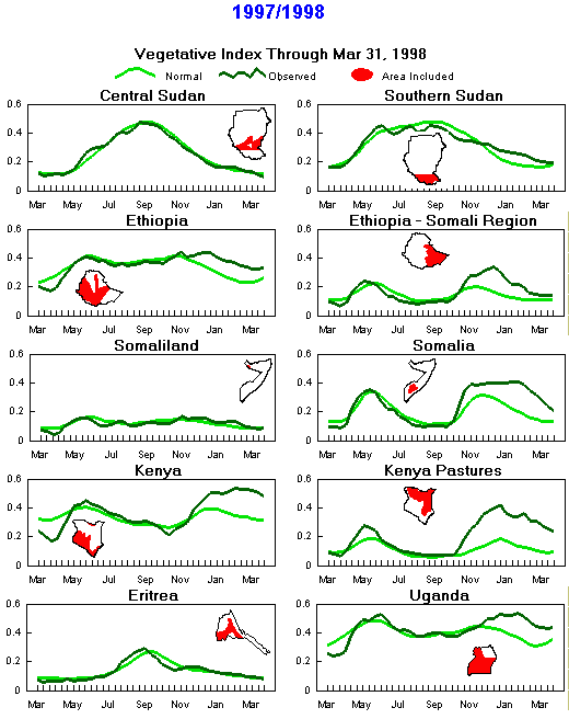
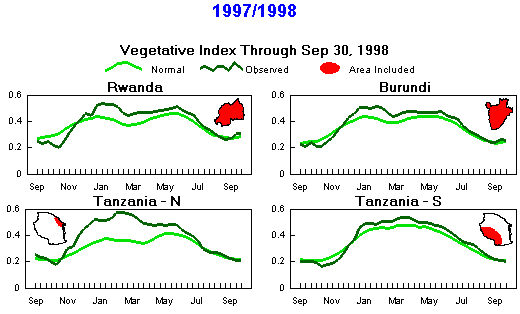
Seasonal Vegetation Index
(Note differences in months due to timing of seasons)
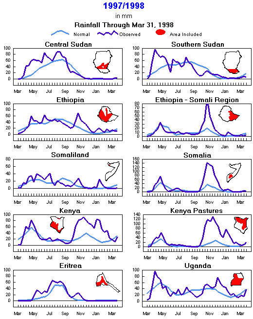
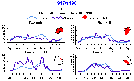
Seasonal Rainfall
(Note differences in months due to timing of seasons)
Current season
|
Back to historical analysis main page
Preliminary Monthly Weather Analysis
Eastern Africa and the Horn
From the African Desk, Climate Prediction Center, NOAA
Note: This information should be used with caution.
Weather data based on preliminary reports.
-
September 1998 - Moderate to heavy rains (50-255 mm) covered central Ethiopia and extended to southern Eritrea and eastern and central Sudan. Eastern Uganda and the western Kenya highlands continued to receive moderate rainfall (40-140 mm; 40-160% of normal). Elsewhere, less than 40 mm were recorded. Meteosat estimates indicated a pocket of heavy rainfall (150-300 mm) over northwestern Ethiopia and adjacent border areas of Sudan. Temperatures were near normal over most countries except northern Tanzania, where -1 to -3 degree C departures were reported. >
- September 21-30 1998 - Heavy rains (90-120 mm; 120-200% of normal) resumed over western Ethiopia. A notable reduction in rainfall occurred over western Sudan. Moderate rains (20-60 mm; 60-320% of normal) fell over eastern Sudan, eastern Ethiopia, western Kenya, and extreme northern Tanzania. The rest of the region reported fewer than 20 mm of rainfall. Satellite imagery indicated an easing of rains over Sudan with moderate falls (25-100 mm) restricted to southwestern and southeastern border areas. Estimates also indicated moderate amounts (25-100 mm) over southeastern Eritrea. In general, totals diminished over previously wet areas of Rwanda, Uganda, and Kenya, estimates ranging from 20 to 50 mm. Temperature departures of -1 to -3 degrees C covered most countries with the exception of Sudan, where temperatures averaged 1 to 3 degrees C above normal.
-
September 11-20 1998 - In East Africa, moderate to heavy rains (30-140 mm; 100-560% of normal ) fell over western Ethiopia and western Sudan (Darfur). Satellite imagery continued to indicate moderate rainfall over southwest Sudan, with the moisture spreading into southeastern Sudan during this period. Estimates indicated rainfall easing (less than 100 mm) over the border area of Eritrea, Ethiopia, and Sudan. Amounts diminished across western Ethiopia and eastern Sudan, lessening the flood threat along the Blue Nile in Sudan. The rest of the region remained seasonably dry except for Uganda and Rwanda, where estimated amounts ranged from 25 to 50 mm. Temperatures ranged from 1 to 3 degrees C below normal over eastern Ethiopia and northern Tanzania. Above normal temperatures covered eastern Sudan and western Kenya.
-
September 1-10 1998 - Rainfall diminished in Sudan and Ethiopia. Western and eastern parts of central Sudan registered moderate rainfall (25-75 mm; 80-300% of normal), but Kordofan saw lower amounts (0-40 mm). Satellite imagery depicted amounts ranging from 25 to 100 mm over southwest Sudan. Estimates indicated heavy rainfall (120 mm plus) over the border area of Eritrea, Ethiopia, and Sudan. Estimated rainfall was seasonable over the remainder of Ethiopia and Eritrea, as well as Kenya and Uganda. The rest of the region remained seasonably dry except for some locations around Lake Victoria in southern Uganda and northern Tanzania. Temperatures ranged from 2 to 4 degrees C below normal over northern Ethiopia to near normal elsewhere in East Africa.
-
August 1998 - Light to moderate rains (30-140 mm; 30-196% of normal) fell over eastern Uganda and the western Kenya highlands. Meteosat estimates indicated moderate to heavy rains (150-300 mm) across central and northwest Ethiopia and Eritrea. In Sudan, while the month started somewhat dry, crop areas were recording plentiful rains by late August. Elsewhere, less than 30 mm were reported. Temperatures were near normal but 2 to 4 degrees C below normal over much of Tanzania.
-
August 21-31, 1998 - For the third consecutive 10-day period, moderate to heavy rains continued to douse border areas of east Sudan and central and western parts of Ethiopia and its southern highlands. Rainfall amounts ranged from 50 to 120 mm (50-300% of normal). Abundant rains continued over Eritrea. Also, unseasonably heavy rains (40-70 mm) fell in Djibouti, according to satellite imagery. The Ogaden in Ethiopia also observed above-normal rains (15-40 mm). Light to moderate rainfall continued to prevail over western Kenya and most of Uganda (5-60 mm) while the rest of East Africa remained seasonably dry. Satellite imagery depicted amounts ranging from 50 to 125 mm over southwest Sudan, including adjacent border areas of D. R. Congo and Central African Republic. Widespread rains covered Sudan's crop areas. Temperatures ranged from 2 to 4 degrees C above normal over northern Sudan to near normal over the rest of East Africa except in eastern Ethiopia and central and southern Tanzania, where they averaged 2 to 4 degrees C below normal.
-
August 11-20, 1998 - Moderate to heavy rainfall continued to pound border areas of east Sudan and central and western parts of Ethiopia, spreading to the southern highlands. Amounts ranged from 60 to180 mm (50-200% of normal). In Sudan, while station data show spotty dryness in Darfur, Kordofan, and the southwest, some satellite imagery suggests normal to above-normal rainfall over these areas. Otherwise, satellite data indicate abnormally heavy rains (25-100 mm) in southeastern Sudan. The season has been below normal in central Sudan, characterized by a slow start to the rainy season and persistent high temperatures. In Eritrea, heavy rains (40-120 mm) fell in the southwest. Over western Kenya and most of Uganda, rainfall was light to moderate (10-50 mm). The remaining areas of East Africa were seasonably dry. Temperatures averaged 2 to 3 degrees C above normal in northern Sudan and 2 to 3 degrees C below normal over Uganda and western Kenya.
-
August 1-10, 1998 - Central and western parts of Ethiopia and border areas of Sudan continued to feature moderate to heavy rainfall (50-120 mm; 80-250% of normal). High-elevation areas of Ethiopia reported very heavy rainfall, in excess of 170 mm. Southeastern Sudan received below-normal rainfall (5-40 mm; 10-70% of normal). Western Kenya and eastern Uganda measured light rainfall, in the range of 10 to 25 mm. Remaining areas of East Africa were seasonably dry. Temperatures were 2 to 3 degrees C above normal in northern crop areas of western Sudan and near normal elsewhere. However, from the desert areas of Sudan northward to Egypt, extreme heat prevailed, with temperatures averaging 3 to 5 degrees C above normal.
-
July 1998 - Northeastern Ethiopia measured mostly above-normal rains (60-420 mm; 80-140% of normal). Over southern Sudan, amounts of 50 to 240 mm were seasonable. In central Sudan, most crop areas ended up with near-normal rainfall totals for the month, though some dry pockets persisted in Darfur and Kordofan and other areas endured excessive rains. Western Kenya and central Uganda amounts ranged from 20 to 180 mm (20-120% of normal). Temperatures were near normal except in Tanzania, where readings were 2 to 3 degrees C below normal.
-
July 21-31, 1998 - Significant amounts of rain continued to fall over eastern Eritrea, central and northeastern Ethiopia, and adjacent border areas of Sudan, where amounts varied from 60 to 210 mm (50-300% of normal). Elsewhere, rainfall over much of southern Sudan remained seasonable, according to satellite estimates, ranging from under 25 mm near Uganda's border to 100 mm farther north. Heavy rains hit some central areas of Sudan, causing flooding in Darfur, with amounts up to 165 mm in the eastern sorghum areas. Rainfall was light to moderate over western Kenya and Uganda (3-30 mm). Temperatures were near normal over Kenya and Uganda, but 3 to 5 degrees C below normal over much of Tanzania.
-
July 11-20, 1998 - The bulk of central and northeastern Ethiopia and central and southern Sudan measured significant amounts of rainfall (60-180 mm; 80-200% of normal). The rains in Sudan eased dry conditions, but cumulative amounts in central areas from Darfur to Kassala remain below normal. In addition, high temperatures continued to increase evaporation across central Sudan. Moderate to heavy rains, ranging from 40 to 120 mm, fell over western Kenya and Uganda. Temperatures over much of Sudan and northeastern Ethiopia ranged from 2 to 3 degrees C above normal, but were near normal over the rest of East Africa.
-
July 1-10, 1998 - Rains improved significantly across central Sudan, with 10 to 60 mm widespread from Kordofan east to Kassala. Nevertheless, amounts were variable, and some locations, especially in the west (Darfur), recorded under 10 mm. Also, temperatures remained unusually high, averaging 2 to 3 degrees C above normal across central areas, maintaining high evaporation rates. More consistent rains are needed to eliminate the deficits that have accumulated since May. In southern Sudan, where rainfall appeared to be the most widespread since late May, satellite estimates indicated moderate to heavy rains (25-100 mm). Heavy rains (50-125 mm) covering crop areas in Ethiopia and Eritrea likely signaled the start to the main rainy season in this region. Light to moderate rains fell in western Kenya (10-50 mm), while satellite estimates indicated below-normal amounts (0-10 mm) for the second consecutive 10-day period in northern and central Uganda.
-
June 1998 - Variable but mostly above-normal rains (30-400 mm; 80-500% of normal) fell in central and western Ethiopia as well as the central and coastal areas of Kenya. Sudan continued to accumulate rainfall deficits, featuring light rains (2-69 mm; 5-40% of normal) in the cental and eastern areas. Southern Sudan fared better, and some areas in the south received moderate to heavy amounts (40-200 mm). Temperatures averaged 2 degrees C above normal over Sudan and near normal elsewhere.
-
June 21-30, 1998 - Hot weather intensified dryness across central Sudan, where no significant rain fell north of the 12th parallel. Rainfall has been abnormally low since May in central Sudan, with dry conditions covering agricultural areas of Northern Darfur, Northern Kordofan, White Nile, Blue Nile, El Gezira, and Kassala. Showers dropped 2 to 20 mm of rain (5-40% of normal) farther south, near the 10th parallel, and totals ranged from 10 to 50 mm across southern Sudan. Heavy rains (50-100 mm) fell near the border with the Central African Republic. Widespread rains are needed soon to avoid drought across central Sudan. Most other parts of East Africa recorded normal to above-normal rains. Moderate to heavy rains (50-180 mm; 90-260% of normal) fell in western and southwestern Ethiopia. Little or no rain fell over eastern Ethiopia and Somaliland, an area that has seen little moisture since late May. Most areas of Kenya (including the seasonably dry north) experienced moderate rainfall (20-170 mm; 65-600% of normal). The near equatorial trough over the Indian Ocean enhanced rainfall along the eastern African coast from northern Tanzania to Somalia, where rainfall ranged between 25 and 170 mm. The rains relieved dryness in Somalia, which had been experiencing a shortfall since May. Interior eastern Kenya and Tanzania, as well as Uganda, Rwanda, and Burundi, remained seasonably dry. Temperatures averaged 2 to 4 degrees C above normal in central and eastern Sudan while western Uganda was 3 degrees C below normal.
-
June 11-20, 1998 - Rains brought some relief from recent heat and dryness to central Sudan, advancing north of the 11th parallel into the mechanized sorghum areas in the east and the traditional crop areas to the west in Darfur and Kordofan, but amounts (1-50 mm) tended to be below normal while temperatures remained high. Rainfall has been below normal across central Sudan since mid-May. Moderate to heavy rains (90-205 mm; 125-165% of normal) fell over southwestern Ethiopia, while central and southern areas of Ethiopia, southeastern Sudan, western Kenya, and southeastern Uganda measured light to moderate amounts (25-100 mm; 70-120% of normal). Satellite imagery depicted heavy thunderstorms originating from the Ethiopian highlands advancing westward across southern Sudan on June 15 and 16. Seasonably dry weather persisted over much of Somalia, coastal and northeastern Kenya, Tanzania, Rwanda, and Burundi. Showers fell in southern Somalia from the equator southward, while rainfall remained negligible over Somaliland, northeastern Ethiopia, and pastoral areas of eastern Ethiopia for the 4th week. Temperatures averaged 2 to 3 degrees C above normal in central and northern Sudan, while Tanzania experienced lower-than-normal temperatures (-2- to -4-degree C departures).
-
June 1-10, 1998 - Light to moderate rains (15-90 mm; 70 ->200% of normal) covered southwestern Ethiopia, central and western Kenya, and southern Sudan. Satellite imagery indicated heavy thunderstorms advancing westward across southern Sudan on June 4. In contrast, rainfall was spotty north of the 11th parallel in central Sudan from Kordofan to Kassala for the second consecutive 10-day period. Temperatures averaging 2 to 4 degrees C above normal from Darfur in the west to Kassala in the east intensified dryness. Seasonably dry weather prevailed over Somalia, coastal and northeastern Kenya, much of Tanzania, Rwanda, and Burundi. In southern Somalia, the early end of the rains during the first half of May reduced the duration of the growing season to about 5 weeks. Dryness has covered Somaliland, northeastern Ethiopia, and pastoral areas of eastern Ethiopia (Ogaden) for the past 3 weeks.
-
May 1998 - Rainfall was below normal (20-100 mm; 20-60% of normal) over much of Rwanda, Burundi, northern Tanzania, and coastal Kenya. In contrast, central, western, and southern Ethiopia and central and western Kenya recorded normal to above-normal rainfall (50->180 mm; 75-600% of normal). Amounts were excessive in central Kenya, with up to 467 mm reported in the Nairobi area, the second-wettest May in 45 years of record. In southern Sudan, rainfall increased during the month, according to satellite estimates. Monthly totals appeared to be near normal (100-200 mm) in southwestern Sudan, with lower amounts in the southeast. Temperatures were near normal over East Africa except in Sudan, where readings averaged 2 degrees C higher than normal over a large part of the country.
-
Late in the month, the rainy season appeared to have ended prematurely across eastern areas of East Africa, with dry weather overspreading southeastern Ethiopia, Somalia, and coastal areas to the south. Light to moderate rains (15-110 mm; 70-200% of normal) covered southwestern Ethiopia and central and western Kenya, but dry conditions prevailed over coastal and northeastern Kenya, Rwanda, Burundi, Somalia, and much of Tanzania, with amounts less than 10 mm. These areas began to experience a steady decrease of rain at the beginning of the month. Satellite estimates indicate that rainfall shut off across southern Somalia after May 10 from the Shebelli River southward. The main-season rains typically last until late May or early June, so the season ended some 3 to 4 weeks early. Moisture conditions are better across northern Somalia and southeastern Ethiopia, thanks to heavy rainfall during May 11-20. Satellite estimates depicted seasonably heavy showers over southern Sudan on May 21-31, but rainfall was spotty (0-25 mm; 0-40% of normal) in central areas north of the 10th parallel from Kordofan to Kassala. Estimated rainfall ranged from 10 to 100 mm across northern Democratic Republic of the Congo (formerly Zaire). Temperatures averaged 1 to 3 degrees C above normal across Kenya, Uganda, Ethiopia, and Sudan.
-
Through midmonth, light to moderate rains (15-75 mm; 60-200% of normal) fell across southern and western Ethiopia, central and southern Sudan, central and western Kenya, and southeastern Uganda. The rains were especially significant for southern Sudan, which had experienced a late onset of rains this season. Rains were below normal along the coast of Kenya and over much of northern Tanzania, where amounts ranged from 0 to 40 mm (0-50% of normal). This downward trend since the beginning of the month may mark an early cessation of the seasonal rains in these countries. Satellite estimates indicated that rainfall was above normal over northeastern Somalia, with amounts ranging from 50 to 100 mm. Reduced rain fell over southern Somalia, where satellite estimates revealed generally dry conditions. Estimated rainfall continued to diminish from earlier high levels across western and northern Democratic Republic of the Congo (the former Zaire). Southern and central areas remained dry.
-
April 1998 - Rainfall was below normal over western Ethiopia, Uganda, Rwanda, Burundi, and parts of western and central Tanzania. Amounts were mostly near normal elsewhere across East Africa, an exception being the unusual wetness along the coast of Kenya and Tanzania. Satellite-estimated rainfall totaled over 300 mm in northeastern Democratic Republic of the Congo-well above the normal value of around 200 mm.
-
In late April, heavy rains hit the coastal areas of Kenya and Tanzania, with amounts ranging from 125 to 455 mm (150->250% of normal). The unusual wetness began around April 20. Over Rwanda, Burundi, western and central Tanzania, northwestern Kenya, and much of Uganda, rainfall was well below normal (0-25 mm; 0-40% of normal). However, affected areas in Tanzania, Rwanda, and Burundi received substantial rains during the preceding 10-day period. The dryness has been more persistent in Uganda, where an area in the southwest adjacent to Lake Victoria appears to have been drier than normal since early April. Below-normal rainfall persisted in western Ethiopia (0-10 mm; 0-12% of normal), where amounts have been below normal since mid-March. Rainfall was seasonably heavy elsewhere in Ethiopia, ranging from 25 to 100 mm (60-200% of normal). The rain broke a nearly 2-month-long dry spell in central Ethiopia, which received less than half its normal rainfall from mid-March through the 3rd week of April. Estimates from satellite images indicated that moderate rains (25-100 mm) covered central and southern Somalia, where the current rainy season has progressed normally. Estimates also indicated that rainfall was seasonally heavy across southern Sudan. Rainfall has been near normal for the past 3 weeks there, although the onset of rains was delayed beyond the start of April. Abnormally heavy rains extended from western to northeastern Democratic Republic of the Congo; estimated amounts exceeded 200 mm in parts of the northeast.
-
In early April, the seasonal rains have been slow to progress northward. As a result, recent rainfall has been below normal from the Central African Republic eastward through southern Sudan into Ethiopia. The period of below-normal rains has persisted since about March 11 across most of Ethiopia, resulting in cumulative rainfall amounts of 25% to 50% of normal over the belg-crop-growing areas. Rainfall picked up during April 1-10, especially in the far south, but totals of 10 to 25 mm over belg crop areas were still below normal. Year-to-date totals remain near normal, thanks to plentiful rains earlier in the year, so drought has not yet become established, but rainfall over the next few weeks should be closely monitored. Satellite estimates indicate that southern Sudan was almost completely dry this period. This follows only light rainfall in March. According to satellite data, this is part of an area that has seen below-normal convection for the past month that stretches from the Guinea Gulf countries eastward through southern Chad, the Central African Republic, and southern Sudan and northeastward through Ethiopia into the Saudi peninsula. Southern Sudan areas such as Equatoria Province should be seeing substantial rainfall by early April. Last year, estimated amounts exceeded 100 mm across much of Equatoria during April 1-10. This is another area that should be monitored in coming weeks to determine if dryness persists into the southern Sudan growing season. Elsewhere in eastern Africa, widespread showers over the southern third of Somalia marked the start of the main rainy season. These rains coincide with the usual start of the season.
-
March 1998 - Early in the month, Ethiopia had good rains in the highlands, but it was drier by midmonth through the end of the month. Eritrea was seasonably dry, as was Djibouti, although there were some light rains in southern areas of Djibouti early in the month. Tiny patches of very light rain fell in southern Sudan starting early in the month but did not expand into larger areas and better rainfall levels, as would have been expected normally. Very light to light rains began to move into southern Somalia by midmonth. Good rains fell in a small border area late in the month. Somaliland was seasonably dry. Through midmonth, Kenya had only light to very light rains over much of the area, but early in the month there were good rains northeast of Lake Victoria, and late in the month good to heavy rains fell across much of the southeast and central area. Early in the month, Tanzania had good to heavy rains in the west, light to good rains in the south, and only light rains in the north. By midmonth the good to heavy rains had retreated to the far south, leaving much of the center area dry. Only light rains fell in the north and west (with a patch of good rains at Singida). Late in the month, good to heavy rains continued along the coast and heavy rains fell in the west. The central area remained dry and was much drier than normal. Uganda had some good rains near Lake Victoria, but other areas were dry or had only light rains, although there were some small, isolated patches of good rains in the north late in the month. The north is drier than normal. Rwanda had good rains in the east and south early in the month, but only light to very light rains from midmonth on. Burundi had generally good rains early in the month, only light rains during midmonth, and good to heavy rains returned by the end of the month with the heaviest rains in the east.
-
February 1998 - Ethiopia was generally dry throughout the month, but the southern highlands had good rains at midmonth. Heavy rains fell in southern Kenya during the first half of the month, and light rains moved into the northwest at midmonth, but general dryness prevailed late in the month. This was the first reprieve from dryness since October 1997. Tanzania began the month near normal, had heavy rains during midmonth, and was drier than normal at the end of the month. Southern Sudan, Somalia, and Somaliland were seasonably dry. Uganda started the month somewhat above normal in the east but was somewhat below normal by midmonth. By the end of the month, only the far south near the lake had good rains. Burundi and Rwanda were near normal early in the month, but increased to above-normal levels by midmonth and decreased toward the end of the month, with Burundi becoming quite dry.
-
January 1998 - Heavy rains continued in Kenya. Heavy rains were also experienced in midmonth in Somaliland, Tanzania, Rwanda, and Burundi, but these had tapered to near-normal levels by the end of the month. Ethiopia and southern Sudan continued near-normal levels, but Ethiopia did begin to experience dryness later in the month. Early heavy rains in Uganda and above-normal rains in Somalia tapered to normal levels later in the month.
-
December 1997 - The heavy rains tapered somewhat but still remained far above normal in Kenya. By the end of the month, Somalia and Ethiopia had returned to normal levels. Rains increased to very high levels in Uganda and continued throughout the month. All of these countries have reported flooding. Southern Sudan remained somewhat above normal, and Tanzania was somewhat above normal but dropped to normal levels at the end of the month. Rwanda and Burundi both dropped to levels far below normal during the month. Somaliland is seasonably dry.
-
November 1997 - Very heavy rains continued through the end of November in most of Kenya, southern and coastal Somalia, southern and western Ethiopia, and north-coastal Tanzania. This is very unusual for this time of year, and such heavy rains are unusual at any time. Flooding has been reported in Kenya, Ethiopia, and Somalia. Rains have been particularly heavy in southern Somalia, where flooding has been widespread and devastating.
-
October 1997 - Rains improved in early October in most areas. Only southern Sudan remained below normal heading into its dry season. Very heavy rains started in mid-October in western Ethiopia. These heavy rains moved from western Ethiopia toward the end of the month, expanding into Kenya, southern and coastal Somalia, southern and eastern Ethiopia, and north coastal Tanzania.
-
September 1997 - Rains were below normal in all areas except Tanzania and Rwanda. Uganda and Somaliland were especially dry, although Ethiopia, Kenya, and southern Sudan were also below normal.
Back to top
|
Current season
|
Back to historical analysis main page
|