Current season
|
Back to historical analysis page
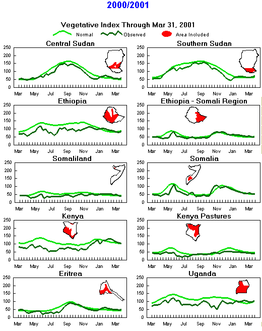
Seasonal Vegetation Index
(Note differences in months due to timing of seasons)
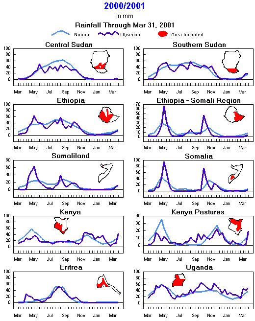
Seasonal Rainfall
(Note differences in months due to timing of seasons)
Current season
|
Back to historical analysis page
Preliminary Monthly Weather Analysis
Eastern Africa and the Horn
From the African Desk, Climate Prediction Center, NOAA
Note: This information should be used with caution.
Weather data based on preliminary reports.
-
September 2001 - Heavy rains (150-250 mm) fell in southwestern Sudan and in pockets of central Sudan, aggravating the river flooding that started in August. Moderate rains (50-102 mm; 71 to 112% of normal) fell in other areas of central and eastern Sudan. Locally heavy rains (up to 220 mm) fell over central Uganda and northwestern Ethiopia, causing flooding in low-lying areas. According to satellite estimates, other parts of Uganda (except the northwest), Rwanda, Burundi and a small strip along Lake Tanganyika on the western side of Tanzania accumulated light to moderate rainfall (25-100 mm). As in August, western Kenya saw heavy rains (108-271 mm; 98-445% of normal), some of which were associated with hail damage to tea farms in Kericho district. Abnormally dry weather extended from the southeast coast of Kenya to northeast Tanzania, with rainfall amounts only 2 to 14% of normal. Satellite estimates also indicated below-normal rainfall for central Ethiopia. >
- September 21-30 2001 - Surface reports and satellite estimates indicated locally heavy rains (115 mm, 137-622% of normal) over western Kenya and parts of northern Uganda. Moderate showers (38-89 mm) fell locally over central and southern Sudan, most of Uganda, Rwanda, Burundi and extreme western Ethiopia. Scattered light rains fell over central and northern Somalia, but southern Somalia remained dry. The minor (deyr) rainy season typically starts around late September or early October in Somalia. Abnormally dry weather covered the southeast coast of Kenya and the northeast coast of Tanzania, as amounts of 0 to 1 mm contrasted with normal totals of 20 to 25 mm.
-
September 11-20 2001 - Surface reports and satellite estimates indicated locally heavy rains (128 mm) over southwestern Kenya. Moderate showers (80 to 166% of normal) fell locally over central and southern Sudan, northern Uganda, Rwanda, Burundi and extreme western Ethiopia. For other parts of central Sudan, northeastern and central Ethiopia and northern Somalia, rains were generally light.
-
September 1-10 2001 - Significant showers (80 to 158% of normal) fell locally over east-central Sudan and western Ethiopia. For other parts of central and southern Sudan, northeastern Ethiopia and isolated areas of northwestern and southern Somalia, amounts ranged between 2 and 25 mm. Estimated totals (1-25 mm) were below normal in eastern Darfur Province in western Sudan, an area that has seen erratic rainfall during much of the season. According to satellite estimates and ground reports, most of Uganda and western Kenya recorded moderate showers, with heavy rains of 75 to 100 mm just north of Lake Victoria in Uganda.
-
August 2001 - Heavy rains (150-250 mm) fell along the Nile Basin in east-central Sudan, contributing to river flooding, and in southwest Sudan (150-300 mm), while moderate rains (52 to 179 mm; 77 to 144% of normal) fell in central and west-central Sudan. Locally heavy rains (up to 150 mm) fell over northern Uganda and northwestern Ethiopia (up to 300 mm). Unseasonable rains fell over western Kenya (103 to 323% of normal).
-
August 21-31 2001 - Heavy showers (up to 150 mm; 155 to 200% of normal) fell over east-central Sudan, contributing to additional river flooding, while lighter rains fell in the southeast. According to satellite estimates and surface reports, northern and central Uganda and western Ethiopia measured light to locally moderate showers, with heavy rains (75-150 mm) north and west of Lake Tana in northwestern Ethiopia. Estimated amounts have been below normal since mid-August in central and southwestern Ethiopia.
-
August 11-20 2001 - Moderate to heavy showers (17-123 mm; 46-604% of normal) fell over most of Uganda, southern and east-central Sudan, western Ethiopia, Burundi, Rwanda and western Kenya. Seasonably light rains (less than 10 mm) fell over southern and eastern Ethiopia.
-
August 1-10 2001 - Heavy showers (115-142 mm, 194-214% of normal) pounded southern Sudan, while light to moderate rains (3 - 87 mm; 15 - 128% of normal) dampened the remaining of Sudan, western and central Ethiopia, northern Uganda and central Kenya. Seasonably dry conditions prevailed over Tanzania. Satellite rainfall estimates indicated seasonable dryness over much of Somalia. Temperatures were Temperatures were generally 1 to 3 degrees C above average across much of Sudan. While they were 1 to 2 degrees C below average over Ethiopia, Uganda, and Tanzania, readings were near average across much of Kenya.
-
July 2001 - Light to moderate rains (1-150 mm, 17-127% of normal) fell in central Sudan, Uganda, coastal and western Kenya, and the northeastern coast of Tanzania. Isolated heavy rains (207 mm, 151% of normal) fell in central Sudan. Satellite estimates indicated abundant seasonal rains across central, northern and western Ethiopia. Light rainfall over northern and eastern interior Kenya had no impact on severe long-term rainfall deficits, and no relief is expected until the seasonal rains begin in October. The drought areas of northern interior Tanzania remained dry. Somalia and eastern Ethiopia recorded seasonably dry weather. Temperatures were normal except in central and northern Sudan, where readings averaged 2 degrees C above normal.
-
July 21-31 2001 - Seasonably dry weather continued in northern Sudan, Somalia, extreme eastern Kenya and Tanzania. Satellite estimates of precipitation indicated that northern, western, and central Ethiopia picked up between 50 and 150 mm while Eritrea's rainfall ranged from 0 mm at the coast to near 100 mm in the southwest. Light to moderate rains (1-65 mm; 4-368% of normal) fell in central and southern Sudan, Uganda, western Kenya and northwestern and coastal Tanzania. Long-term rainfall deficits continued over interior Tanzania and Kenya as well as southern Ethiopia and parts of northern Ethiopia. Marsabit, in northern Kenya, has reported less than one-fourth normal rainfall both in the past 3 months and the past 12 months. Temperatures averaged 2 degrees C below normal in northwestern Somalia but 2 to 4 degrees C above normal in central and northern Sudan and isolated places in northern and southern Tanzania.
-
July 11-20 2001 - Moderate rains (10-75 mm) eased dryness over central Sudan, while moderate to heavy showers (50-100 mm) fell over western and northern Ethiopia, western Eritrea and southern Sudan. Moderate to heavy rains (30-110 mm; 124-450% of normal) fell over most of Uganda, western Kenya, northern Tanzania, Rwanda and Burundi.
-
July 1-10 2001 - A lagging ITCZ maintained below-normal rainfall, high temperatures and low humidities over the northern crop areas of Sudan, particularly in the western half. Moderate rain (10-74 mm; 62-152% of normal) fell over south-central Sudan and western Ethiopia.
-
June 2001 - Conditions were seasonably dry except for above-normal rains in Uganda and western Kenya and below normal rains in west-central Sudan and northern Ethiopia. Light to moderate rains (38-153 mm; 35-149% of normal) fell over central and southern Sudan, western Ethiopia (52-131 mm; 26-50% of normal), northern and eastern Uganda and southwestern Kenya (25-183 mm).
-
June 21-30 2001 - Light to moderate rain (1-40 mm; 4-80% of normal) fell over southern Sudan, western Ethiopia, most of Uganda and southwestern Kenya. Rains were below normal from northern Ethiopia into southern Eritrea, according to satellite estimates, indicating the second season may be slow to start from Shewa northward to Tigray in Ethiopia.
-
June 11-20 2001 - Moderate to heavy showers (40-136 mm; 60-342% of normal) fell over western Ethiopia, southern Sudan, northern and eastern Uganda and southwest Kenya. Satellite estimates indicated excessive amounts exceeding 150 mm in parts of southern Sudan. Seasonally dry weather allowed dry conditions to persist over Somalia and eastern Ethiopia. Northern and eastern Kenya, Tanzania, Rwanda and Burundi were seasonably dry.
-
June 1-10 2001 - Moderate showers (50-100 mm; 90-199% of normal) fell over western Ethiopia, southern Sudan, northern and eastern Uganda and southwest Kenya. Dry conditions persisted over eastern and southern Ethiopia, Somalia, northern and eastern Kenya and much of Tanzania, but amounts are typically low during this time of the year. Rwanda and Burundi recorded less than 10 mm. Temperatures averaged 2 to 4 degrees C below normal over northern and southern Uganda and southeastern Kenya. Readings averaged 2 degrees C above normal over eastern Sudan.
-
May 2001 - Moderate to heavy showers fell in western and south-central Ethiopia (69-300 mm; 94-236% of normal), southwestern Sudan (150-250 mm; 100-150% of normal), eastern Uganda and southwestern Kenya (126-234 mm; 82-88%), coastal Kenya, coastal Tanzania and extreme southern Somalia (50-100 mm). Abnormally dry weather, with rainfall totals 50% of normal or less, prevailed in northern Kenya and in parts of western, central and southern Kenya; southeastern and extreme southern Ethiopia, including the Somali region; central Somalia; and central Tanzania. Rainfall was below normal (25-65 mm; 50-75% of normal) in Rwanda, Burundi, northwestern Tanzania, southwestern Uganda and northern Somalia. Satellite estimates indicated pockets of below-normal rainfall in central and northern Ethiopia, especially in Tigray. For February through May, preliminary rainfall estimates for the African Horn show a generally below normal season, with cumulative rainfall under 50% of normal in the Somali region of Ethiopia and 50 to 80% of normal across much of Somalia, Kenya, Tanzania, Rwanda and Burundi. The (belg) crop areas in Ethiopia measured generally average rainfall, but satellite estimates suggested locally below-normal rainfall in the north. Monthly temperatures averaged near normal, except 2 to 3 degrees C below normal over Ethiopia.
-
May 21-31 2001 - Moderate rain (22-100 mm; 117-845% of normal) fell over west-central Ethiopia, east-central, southern and south-western Sudan, western Kenya and eastern Uganda. Dry conditions persisted over eastern Ethiopia, southern Somalia and central Tanzania. The remainder of Somalia recorded light rain (less than 5 mm). In most of Somalia and adjacent Ethiopia, the rainy season ended somewhat early (around May 10) and began somewhat late, resulting in a shortened season. Most of Uganda and northern Kenya recorded less than 50% of normal rainfall. Heavy rain, more than 100 mm, fell over the coasts of Kenya and Tanzania. Light rain (under 25 mm, less than 84% of normal) fell over Rwanda, Burundi and northwestern Tanzania. Temperatures averaged within 1 degree C of normal, except 2 to 4 degrees C below normal over the coast of Tanzania, south-central Uganda and most of Ethiopia. Readings averaged 2 degrees above normal over northeast Kenya and northern Sudan.
-
May 11-20 2001 - Below-normal rains persisted over northwestern and northern Kenya, most of Tanzania, southern Ethiopia and southern Somalia with 0-25 mm totals (0-40% of normal). If this were an early end to the rains in eastern Ethiopia, it could be a concern because of the late start to the season. In contrast, the coasts of Kenya and Tanzania recorded normal to above rainfall (38-183 mm; 93-206% of normal). Estimated rainfall was below normal (12-23 mm; 40-70% of normal) in Rwanda, Burundi and northwest Tanzania, indicating that the rainy season may end early. Moderate rain (14-100 mm, 118-269% of normal) fell over central Ethiopia and southern Sudan. Temperature readings averaged within 1 degree C of normal except 2 to 4 degrees C below normal over extreme southern Kenya, southwestern Tanzania and most of Ethiopia, and 2 to 4 degrees C above normal over central Tanzania, central and southern Sudan and northern Uganda.
-
May 1-10 2001 - Drier weather prevailed in southern, eastern and northern Kenya as well as in southern Ethiopia, southwestern Somalia and western Tanzania. However, southwestern Kenya recorded more than 50 mm of rain, and light to moderate rains (1-28 mm; 1-59% of normal) fell in coastal Kenya and parts of northern Kenya. According to satellite estimates, most of southern Uganda, eastern Tanzania, Rwanda and Burundi received 1-40 mm but significant dryness remained. Near-normal rainfall (25-75 mm) prevailed in central and northern Uganda, southwestern and south-central Kenya, southern Sudan and southwestern Ethiopia. Moderate to heavy rain (75-150 mm; 99-232%) fell in central Ethiopia but most of Somalia measured less than 25 mm and northwestern Ethiopia was dry. Locally heavy rains further relieved dryness in northern Ethiopia. Dry conditions due to abnormally low rainfall in recent weeks persisted over eastern Ethiopia (Somali region) northward into northern Somalia (Somaliland) and southward into southern interior Somalia and eastern and northwestern Kenya. The rainy season has been slow to start across south-central Sudan, where rainfall was negligible this period. Temperatures averaged within 1 degree C of normal, except 2 to 4 degrees C below normal over central Ethiopia; 2 degrees C above normal in eastern Rwanda, southeastern and northwestern Uganda, the north coast of Kenya and northeastern Kenya; and 2 to 4 degrees C above normal over most of Sudan.
-
April 2001 - Reported and satellite-estimated rainfall totaled less than 100 mm (25-50% of normal) in Rwanda, Burundi, northwestern Tanzania and extreme southwestern Uganda. April is typically the wettest month in this region, so the drying trend during the last half of the month was unusual. The seasonal rains paused in northern Ethiopia from late March until late April, resulting in below-normal monthly totals. In eastern Ethiopia and northern Somalia, the rainy season began late, reducing April totals to 0 to 40 mm (1-50% of normal). In contrast, moderate to heavy showers (100-203 mm; 90-103% of normal) fell in Uganda (except the extreme southwest), western Kenya, southern Somalia, southern Ethiopia and southern Sudan. Temperatures averaged around 2 degrees C above normal in Sudan and near to slightly below normal elsewhere.
-
April 21-30 2001 - Satellite estimates and reported totals indicated moderate to heavy rains (30-95 mm; 100-203% of normal) in western Kenya, central Uganda, coastal Tanzania and southern Ethiopia. Beneficial showers (1-50 mm) eased dryness across northern and eastern Ethiopia and northern Somalia (Somaliland), but more rain is needed to end the rainfall deficits. Seasonably heavy rains fell across central and southern Somalia and southern Sudan, according to satellite estimates. Below-normal rains (0-25 mm) continued over central and northern Tanzania, Rwanda, Burundi, southwestern Uganda and central and eastern Kenya. Temperatures averaged within 1 degree C of normal, except 2 to 3 degrees C below normal over most of Ethiopia and 2 to 4 degrees C above normal over most of Sudan and northern Somalia.
-
April 11-20 2001 - The rainy season became established over southern Somalia, as satellite estimates indicated 25 to 200 mm over the south. In contrast, dryness persisted over northern and eastern Ethiopia as well as Somaliland (northern Somalia). In Ethiopia, little rain has fallen from Addis northward since late March. Increased showers fell over parts of eastern Ethiopia in the Somali region, but amounts were mainly under 10 mm and below normal. Before this period, rainfall had been negligible in this region since the start of the year. Satellite rainfall estimates indicated rain exceeding 125 mm in southwestern Ethiopia and southern Tanzania, but amounts were abnormally light (0-25 mm) in Rwanda and Burundi. Heavy showers (24-132 mm; 95-151% of normal) continued over southern Uganda and the Victoria Basin. The rains diminished in southwestern Kenya and central and northern Tanzania as locally heavy rains hit southern Tanzania. Temperatures averaged near normal across the region except 1 to 3 degrees below normal in Ethiopia and 2 to 3 degrees C above normal in Sudan.
-
April 1-10 2001 - Heavy rains (61-83 mm; 100-373% of normal) hit southwestern Kenya, central and northern Tanzania, southern Uganda and the Lake Victoria Basin. Although the rainy season is established over much of East Africa, contributing to long-term drought relief in the pastoral areas, the first season (belg) rains have been erratic over eastern and northern Ethiopia, while the main season main season rains have been slow to penetrate Somalia. Rainfall has been below normal for the season in eastern agricultural areas of Ethiopia and below normal since late March in the north. Satellite-estimated rainfall totals improved in Rwanda and Burundi, as totals ranged from 25 to 75 mm during the 10-day period. Temperatures averaged near normal across the region except 1 to 3 degrees below normal in Uganda, southern Sudan and Ethiopia.
-
March 2001 - Ample rains at months end boosted monthly totals to near or above-normal in most areas. Satellite estimates indicated, however, that monthly rainfall was less than normal in east-central Ethiopia, while above normal to the west. Amounts totaled under 50% of normal in extreme eastern Kenya, but ranged from 100 to 200% of normal in central and western Kenya and much of Uganda, easing long-term drought. Satellite estimates indicated below-normal rainfall in parts of Rwanda and Burundi, especially northern Burundi, as well as in central and northeastern Tanzania.
-
March 21-31 2001 - Heavy rains (46-216 mm; 102-511% of normal) pounded Kenya, northern Uganda, the Lake Victoria Basin and northwestern Tanzania. Heavier rains also hit southern Ethiopia. The increased rainfall eased short and long-term dry conditions in central, southern, and northern Kenya and southern Ethiopia. Satellite data indicated light to moderate showers over southern Somalia. The rainy season appears to have started generally on schedule; however, considerably more rain is still needed to end the severe long-term rainfall deficits over pastoral areas of Kenya. Satellite rainfall estimates indicated rain exceeding 150 mm over the Lake Victoria Basin and 50 mm elsewhere in much of the region. Satellite-estimated rainfall amounts were variable over Rwanda and Burundi, with estimated totals continuing to be below normal across northern and central Burundi and western Rwanda. Temperatures averaged near normal across the region except 1 to 3 degrees below normal in Uganda.
-
March 11-20 2001 - Light to moderate showers (21-28 mm; 109-152% of normal) fell in western Kenya, northern Uganda and west-central and northern Ethiopia. Long-term drought persisted in northern Kenya, while short-term dryness developed in central and southern Kenya, where total rainfall has been under 50% of normal during the past 4 weeks. Satellite rainfall estimates indicated rain exceeding 75 mm in southern Tanzania, but amounts were abnormally light (0-10 mm) in central and northern Tanzania and below normal in Rwanda and Burundi. Satellite estimated amounts have been below normal since mid-February in both countries. Temperatures averaged near normal across the region except 1 to 3 degrees below normal in Uganda.
-
March 1-10 2001 - Moderate-to-heavy showers (27-203 mm; 144-490% of normal) relieved dryness in southwestern Kenya, Uganda and northwestern Tanzania. However, satellite rainfall estimates indicated that long-term dryness persisted in eastern Kenya, Somalia, southeastern and western Ethiopia. Although, Ethiopia's first season (belg) rains began on time in February, rainfall continued to be light in the southwestern and central parts of the country. Temperatures were average across the region.
-
February 21-28 2001 - Rainfall was abnormally light (0-26 mm; 0-25% of normal) over most of Ethiopia, Kenya, Uganda, Rwanda, Burundi and interior northern and central Tanzania, although locally heavy rains struck the northeast coast of Tanzania. Amounts were higher (25-50 mm) but still below normal over southern Tanzania. Ethiopia's first season (belg) rains began on schedule in February, but have been lighter than normal. Long-term drought persisted over Kenya's pastoral areas, northeast Uganda and southern Ethiopia. Most of the annual rainfall typically falls during April-May and November-December in Kenya's pastoral region, so relief was not expected in February. Temperatures averaged near normal across the region.
-
February 2001 - Rainfall totaled under 50% of normal in northern and eastern Kenya and northern Uganda, continuing the multi-year drought. Though the first rainy season appeared to start on time in Ethiopia, rainfall diminished during the month, resulting in below-normal monthly totals.
-
February 11-20 2001 - Heavy rains diminished in Kenya, Uganda, and Tanzania, with only light rains (1-46 mm; 24-105% of normal) falling. To the north, scattered first season (belg) rains continued in Ethiopia, but amounts were light. Long-term drought continued across the pastoral areas of Kenya and adjacent areas in Ethiopia. Temperatures averaged near normal across the region.
-
February 1-10 2001 - Heavy rains (60- 83 mm; 94-280% of normal) fell in western Kenya, southern Uganda, and most of Tanzania, except in the northeast. Amounts were generally less than during the preceding period. Light rains in Ethiopia likely signaled the timely start of the first season (belg) rainy season. Temperatures averaged near normal across the region.
-
January 2001 - Unseasonably heavy rains covered northern Tanzania and southern Kenya, with amounts ranging from 100 to 375 mm (200-700% of normal). In Kenya, these were near or above record monthly amounts. Monthly rainfall was generally below normal (0-30 mm; 0-70% of normal) in north-central and northeastern pastoral areas of Kenya and adjacent parts of Ethiopia. Large long-term rainfall deficits continue in this area.
-
January 21-31 2001 - Heavy rains (40-130 mm; 99-437% of normal) fell in northern Tanzania, southwestern Kenya and southeastern Uganda. Temperatures were near average across the region.
-
January 11-20 2001 - Above-normal rains (75-125 mm) covered much of Tanzania, parts of southern Uganda and southwestern Kenya. Temperatures were near average across the region.
-
January 1-10 2001 - Moderate to heavy rains (34-90 mm; 95-427% of normal) shifted to southern and central Kenya, the Lake Basin, and central and southern parts of Tanzania. Light to moderate rains (1-17 mm; 15-40% of normal) fell over northern Kenya and southern Uganda. Long-term dry conditions persisted over northern Kenya. Temperatures were near average across the region.
-
December 2000 - The Lake Victoria Basin, including northwestern Tanzania, southern Uganda, and southwestern Kenya benefitted from abundant rains (107-182 mm; 96-210% of normal). Heavy rains (106-275 mm; 146-269% of normal) soaked western part of central Tanzania. Moderate rains (33-57 mm; 105-118% of normal) were observed along the Kenyan coast. Lighter rains (5-89 mm; 16-75% of normal) fell over much of Tanzania, northern Uganda, and northern Kenya. Seasonably dryness prevailed over Sudan. Satellite rainfall estimates indicated that the dry spell continued over much of the region, except southern Uganda, the Lake Victoria Basin, southeastern Kenya and Tanzania. Temperatures were near average across the region.
-
December 21-31 2000 - Moderate to heavy rains (27-115 mm; 92-290% of normal) were confined to central Tanzania, the Lake Victoria Basin, and the western half of Uganda. Although Kenya and northeastern Uganda benefitted from good rains the previous 10-day period, long term dryness persisted over much of this sub-region, where only light to moderate rains (1-40 mm; 3-70% of normal) were observed. Rainfall was also light to moderate across much of Tanzania. Seasonably dry conditions prevailed over Sudan. Satellite rainfall estimates indicated that dry conditions prevailed over Ethiopia and Somalia. Temperatures were 1 to 5 degrees C above average across much of the region, except northern Somalia and central Uganda, where they were 1 to 3 degrees C colder than average.
-
December 11-20 2000 - Much of the rains were confined to the region south of the equator. Moderate to heavy rains (25-163 mm; 100-471% of normal) fell in southeastern Kenya, and along the Kenyan and Ugandan shores of the Lake Victoria. Unseasonable rains (6-19 mm; 109-150% of normal) fell over northern Kenya and northwestern Uganda. Light rains (16-37 mm; (35-70% of normal) were observed across much of Tanzania, except the mid-eastern part, which was pounded by isolated downpours (53-122 mm; 249-371% of normal). Seasonable dryness prevailed over Sudan. Satellite rainfall estimates indicated dry conditions over Ethiopia and Somalia. Temperatures were generally near average.
-
December 1-10 2000 - Rainfall totaled 0 to 10 mm (0-50% of normal) across northern and eastern pastoral areas of Kenya and southern Ethiopia, allowing long-term drought to persist. Rainfall was heavier to the south, with moderate to heavy rains (10-120 mm, 75-300% of normal) over Tanzania and the southern parts of Uganda and Kenya. Rainfall amounts have exceeded 200% of normal in the past 4 weeks over much of Tanzania. Satellite rainfall estimates ranged between 0 and 25 mm in southern Somalia. Temperatures were 2 degrees C above normal in south Kenya and 2 degrees C below normal in central Uganda and eastern Tanzania.
-
November 2000 - Above-normal rains eased drought in central and southern Kenya as well as northern Tanzania. Heavy rains (121-235 mm, 120-300% of normal) fell in central and southern Kenya and central and southern Tanzania. Below-normal rains (0-50 mm, 0-60% of normal) fell across northern Kenya and southern Ethiopia. Light to moderate rains (50-98 mm) fell in Uganda, with lighter rains in southern Sudan. Satellite rainfall estimates ranged up to 50 to 100 mm in southern Somalia and western Ethiopia, with seasonably drier conditions in central and northern Ethiopia and Eritrea. Somalias estimated rainfall was near normal except for below normal in interior southern areas near the Kenyan border. Temperatures averaged up to 2 to 3 degrees below normal in eastern Kenya and southern Tanzania, near normal elsewhere.
-
November 21-30 2000 - Moderate to heavy rains (25-100 mm, 100-200% of normal) fell in central and southern Kenya, further easing long-term rainfall deficits. To the north, lighter amounts (0-20 mm, 0-90% of normal) fell in northern Kenya and southern Ethiopia, allowing long-term drought to persist. Widespread rains spread across Tanzania, with amounts ranging from 10 to 30 mm in the north to 50 to 150 mm in central and southern areas. Amounts were mostly seasonable elsewhere in East Africa, including satellite-estimated totals of 1 to 25 mm in southern Sudan and southern Somalia. Temperatures averaged 2 to 3 degrees C above normal in central Sudan and 2 to 3 degrees C below normal in central Uganda and central Tanzania.
-
November 11-20 2000 - Moderate rains (25-100 mm, 9-593% of normal) fell in Uganda, western, southern, and coastal Kenya, southwestern Somalia and much of Tanzania. Satellite rainfall estimates ranged from 10 to 50 mm in southwestern Ethiopia, but estimates indicated little or no rain in the pastoral areas of southern and southeastern Ethiopia and eastern Kenya. This was the second consecutive period with little rain in the southern Ethiopian areas bordering Somalia, signifying that the short rains may have ended early. Up to 50 mm of rain in north-central Kenya further eased long-term drought, but areas farther east were mostly dry. Temperatures averaged 2 to 3 degrees C above normal in central Sudan, northern Kenya and coastal Tanzania.
-
November 1-10 2000 - Light to moderate rains (1-92 mm, 2-289% of normal) fell in Uganda, western and central Kenya and western Tanzania, with moderate amounts (10-50 mm) in southern Sudan. Amounts totaled mainly under 10 mm and 50% of normal in northern, eastern, and southern Kenya and eastern and southern Tanzania. Four-week rainfall totals were less than 25% of normal in southeast Kenya and northeastern Tanzania, indicating a weak start to the second rainy season. Satellite rainfall estimates ranged from 25 to 50 mm in western Ethiopia, but were variable and spotty (0-50 mm) elsewhere in Ethiopia and negligible in Somalia. Temperatures averaged 2 to 3 degrees C above normal in central Sudan, south Kenya and interior Tanzania.
-
October 2000 - Northern portions were mostly wetter than normal while southern areas were seasonably dry. Light to moderate rains (1-90 mm, 1-346% of normal) fell in central and southern Sudan, central Uganda and western Kenya. Heavy rains (111-238 mm) hit northern and southern Uganda. Satellite rainfall estimates ranged from 50 to 150 mm over western Ethiopia, but ranged from 0 to 20 mm in central Ethiopia from Tigray to Shewa. Isolated amounts reached estimated totals up to 100 mm in southern Ethiopia and interior Somalia. Temperatures were 2 degrees below normal in interior Uganda and western Kenya and near normal elsewhere.
-
October 21-31 2000 - Light to moderate rains (1-89 mm, 2-1000% of normal) fell in southern Sudan, Uganda, western and central Kenya, and the border area between southern Ethiopia and Somalia. Satellite rainfall estimates ranged from 10 to 50 mm over western and southern Ethiopia, but continued near zero in central areas. Estimated amounts of 10 to 25 mm offered slight drought relief in northwest Kenya, but rainfall totaled under 10 mm in northern and eastern pastoral areas. Little or no rain fell in all but southwestern areas of Tanzania. Temperatures were 2 to 3 degrees C above normal in eastern Sudan and northern Somalia and 2 degrees C below normal in central Uganda and eastern Kenya. Readings were near normal in the other areas.
-
October 11-20 2000 - Light to moderate rains (1-85mm, 1 B 677% of normal) fell in northeastern Sudan, Uganda, Kenya and northwestern Tanzania. Precipitation estimates from satellite gave 50-100mm of rainfall to western Ethiopia and northern Somalia. Temperatures were near normal except for 2 degrees C above normal in southeastern Sudan and northern Somalia and 2 degrees C below normal in Uganda.
-
October 1-10 2000 - Heavy rains (50-200 mm) falling in Somalia and southern Ethiopia heralded the onset of the short rainy season. Moderate main season rains (50-100 mm) stretched from western Ethiopia to southern Sudan, but the north-central areas of Ethiopia from Tigray to Shewa remained dry. Light to moderate rains (2-92 mm, 2-679% of normal) fell in central and southwestern Sudan, Uganda, and Kenya. Severe long-term rainfall deficits persist in much of Kenya and northern Tanzania. Isolated heavy rains (110 mm, 350% of normal) struck southern Uganda. Temperatures were 2 to 3 degrees C above normal in west and extreme northeast Sudan, 2 to 3 degrees C below normal in central Uganda and western Kenya, and normal elsewhere.
-
September 2000 - Rainfall for the month was generally below normal, with little or no rain in Tanzania, southeastern Ethiopia, interior Kenya and Somalia. Northern crop and pasture areas in Sudan continued to see below-normal rains and above-normal temperatures, with satellite estimates suggesting the driest crop area was in west-central Sudan, including eastern Darfur and western Kordofan. Satellite estimates of both rainfall and vegetation health also suggest some dryness in southern Sudan near western Jonglei. Moderate rains (100-150 mm) fell in southwestern Sudan, central Uganda, and western Kenya. Isolated heavy rains (106-170 mm, 127-475% of normal) fell in north-coastal Tanzania and offered some local drought relief in northeastern Kenya. Satellite estimates indicated below-normal rains for Ethiopia, with 50 to 150 mm in the west and under 50 mm elsewhere. The early end to the main rainy season appears to have occurred in central areas where the season began late, including Wello, Tigray and Shewa, resulting in a shortened rainy season. This is the same area where the minor season rains failed during February to May. Temperatures averaged 2 degrees C above normal in central Sudan but near normal elsewhere.
-
September 21-30 2000 - The long-term rainfall deficits continued in Tanzania, Kenya, and southern parts of Ethiopia and Somalia. Amounts in this region ranged from light to moderate (1-72 mm, 2-384% of normal) in central and southern Sudan, northwestern Somalia, Uganda and western Kenya. Satellite estimation of precipitation indicated 25 to 50 mm in western Ethiopia and mainly 1 to 10 mm in northern and central areas of Ethiopia, where the main rainy season appears to have ended early. No rain fell in northern and eastern Kenya. The largest long-term rainfall deficits exist in northern Kenya, where 12-month cumulative rainfall is as low as 25% of normal. Temperatures averaged near normal everywhere except 2 to 3 degrees C above normal in northern and central Sudan and 2 to 3 degrees C below normal in southern Sudan.
-
September 11-20 2000 - The ITCZ extended farther to the east to trigger light to moderate rains (5-50 mm) across much of southern Kenya and Uganda. Light to moderate rains (2-54 mm; 23-129% of normal) were also observed over much of central Sudan, while seasonably dry conditions prevailed across much of Tanzania. Satellite rainfall estimates indicated dry conditions over much of Ethiopia and Somalia. Temperatures averaged near normal everywhere, except 2 to 3 degrees C above normal in central Sudan.
-
September 1-10 2000 - Long-term rainfall deficits persisted in Kenya, northern Tanzania, and southern Ethiopia and extreme western Somalia. The rains in this region ranged from light to moderate (1-96 mm, 1-360% of normal) over central and southern Sudan, northern Ethiopia, Uganda, and Kenya. Most of Somalia was seasonably dry. Isolated heavy rainfall (107 mm, 448% of normal) struck the northern coast of Tanzania. Temperatures averaged near normal everywhere except 2 to 3 degrees C above normal in central Sudan, Kenya and central Tanzania. The seasons rainfall appears to be below normal in Northern Darfur and Northern Kordofan provinces in central and western Sudan.
-
August 2000 - The rains were a mixture of light to moderate, with 25 to 150 mm (25-75% of normal) in central Sudan, 50 to 150 mm (50-125% of normal) in southern Sudan and Uganda. Above-normal rains in western and central Kenya (50-180 mm, 110-215% of normal) eased
long-term rainfall deficits, but amounts of 20 mm or less elsewhere in Kenya, northern Tanzania, and southern Ethiopia had little impact on the drought. Satellite rainfall estimates indicated more than 200 mm in northern Ethiopia and 100 to 200 mm in interior Eritrea. Temperatures were normal except for 2 to 3 degrees C above normal in central Sudan.
-
August 21-31 2000 - Severe long-term rainfall deficits continued in Kenya, northern Tanzania, and southern Ethiopia. Light to moderate rains (1-37 mm, 2-209% of normal) fell in southern Sudan, Uganda, western Kenya and extreme northwestern Tanzania. The reported rainfall in the sub-region was generally below normal, especially in Sudan, Ethiopia, and Uganda. Key agricultural areas across central Sudan measured mostly under 25 mm of rain, according to satellite data, and temperatures 3 to 5 degrees C above normal accompanied the dryness. Temperatures averaged near normal elsewhere.
-
August 11-20 2000 - Abundant rains (28-90 mm; 137-350% of normal) in the Lake Victoria region, northwestern Uganda and parts of central Kenya offered some relief from the long-term dryness. However, rainfall deficits prevailed along the coast of Kenya and seasonable dryness prevailed across southern and northern Kenya, and Tanzania. To the north, below-normal rains (8-71 mm; 3-36% of normal) fell over western Sudan, while moderate to heavy rains (36-136 mm; 63-217% of normal) hit eastern Sudan. Satellite rainfall estimates indicated heavy rains (100-200 mm) over northwestern Ethiopia, while Somalia remained seasonably dry. Temperatures were generally near average across Uganda, Kenya, and Tanzania. They averaged 2 to 3 degrees C above normal over much of Sudan.
-
August 1-10 2000 - Long-term rainfall deficits continued in interior Kenya and northern interior Tanzania, but unseasonably heavy showers (locally exceeding 50 mm) fell in west-central Kenya. Light to moderate rains (1-77 mm, 4-390% of normal) fell in coastal areas of Kenya, central and southern Sudan, extreme northwestern Somalia and Uganda. Satellite estimates of precipitation totaled 25 to 100 mm over central and northern Ethiopia and between 1 and 25 mm in Eritrea. Rainfall in central Sudan diminished from the prior period, with most crop areas measuring under 25 mm. Rainfall was spotty during the prior period, so some locations are likely becoming quite dry. Temperatures averaged 2 to 4 degrees C above normal in northeastern Sudan, northwestern Kenya and inland Tanzania, but 2 to 3 degrees C below normal in western Kenya and Uganda.
-
July 2000 - Light to moderate rains (1-150 mm, 17-127% of normal) fell in central Sudan, Uganda, coastal and western Kenya, and the northeastern coast of Tanzania. Isolated heavy rains (207 mm, 151% of normal) fell in central Sudan. Satellite estimates indicated abundant seasonal rains across central, northern and western Ethiopia. Light rainfall over northern and eastern interior Kenya had no impact on severe long-term rainfall deficits, and no relief is expected until the seasonal rains begin in October. The drought areas of northern interior Tanzania remained dry. Somalia and eastern Ethiopia recorded seasonably dry weather. Temperatures were normal except in central and northern Sudan, where readings averaged 2 degrees C above normal.
-
July 21-31 2000 - Seasonably dry weather continued in northern Sudan, Somalia, extreme eastern Kenya and Tanzania. Satellite estimates of precipitation indicated that northern, western, and central Ethiopia picked up between 50 and 150 mm while Eritreas rainfall ranged from 0 mm at the coast to near 100 mm in the southwest. Light to moderate rains (1-65 mm; 4-368% of normal) fell in central and southern Sudan, Uganda, western Kenya and northwestern and coastal Tanzania. Long-term rainfall deficits continued over interior Tanzania and Kenya as well as southern Ethiopia and parts of northern Ethiopia. Marsabit, in northern Kenya, has reported less than one-fourth normal rainfall both in the past 3 months and the past 12 months. Temperatures averaged 2 degrees C below normal in northwestern Somalia but 2 to 4 degrees C above normal in central and northern Sudan and isolated places in northern and southern Tanzania.
-
July 11-20 2000 - Seasonably dry weather continued in northern Sudan, Somalia, eastern Kenya and Tanzania. Satellite estimates of precipitation indicated that northern, western, and central Ethiopia picked up between 50 and 150 mm while most of Eritrea recorded less than 2 mm. Light to moderate rains (1-70 mm; 20-189% of normal) fell in central Sudan, Uganda and west central Kenya. Long-term drought continued over interior Kenya, northern Tanzania, and southern Ethiopia. Temperatures were generally near normal except for isolated 3 degrees C above normal in northeastern Sudan.
-
July 1-10 2000 - Seasonably dry weather continued in northern Sudan, southern Ethiopia, Somalia, eastern Kenya and Tanzania. Satellite estimates of precipitation indicated that northern, western, and central Ethiopia picked up 10 to 100 mm. These were the heaviest rains for north-central areas since early May, and likely signal the delayed start of the main season rains. Moderate to heavy rains (10-117 mm; 18-282% of normal) fell in southern Sudan and west-central Kenya. Rains were light (1-6 mm; 30-347% of normal) in southeast Kenya. Little rain fell in drought-affected areas of Tanzania and northern and interior eastern Kenya. Temperatures were generally normal except 2 to 3 degrees C above normal in central Sudan.
-
June 11-20 2000 - Dry weather continued over central and eastern Ethiopia, Somalia and northern Sudan. June rainfall is normally light in much of Ethiopia, but satellite estimates indicate that little rain has fallen since May 1-10 in central and northern areas from Tigray to Shewa, areas that typically see some rain from May into June. Rains usually continue into June over Somalias central and southern coastal areas, but little rain has fallen this month south of Somaliland, according to satellite estimates. Dryness persisted in northern Kenya and much of Tanzania. Light to moderate rains (5-35 mm; 21-138% of normal) fell over southern Kenya, northern Tanzania and Uganda. Satellite data and surface measurements indicated moderate to heavy rains (up to 111 mm; 512% of normal) over the coast of Kenya and Tanzania. Severe drought continued over interior Kenya and southward through northern Tanzania while drought persisted in northern Ethiopia. Satellite estimates have depicted little rain over southern Sudan so far this month, especially over Jonglei. Temperatures were generally close to normal over the region.
-
June 1-10 2000 - Drought persisted over interior parts of Kenya and Tanzania, as well as southern Ethiopia. Seasonably dry weather covered Somalia and northern Sudan. Light to moderate rain (4-38 mm; 9-96% of normal) fell in Uganda and western Kenya while moderate to heavy rain (20-125 mm; 50-300% of normal) fell over coastal Kenya and Tanzania as well as western Ethiopia. Up to 10 mm (156% of normal) dampened northern Kenya, an area that has reported little rain this year. Satellite data indicated moderate rains in southern Sudan and northern Uganda and seasonably dry weather in central and southern Somalia. Most of the eastern two-thirds of Ethiopia has seen little rain since May 11. A break between the first (belg) season and main season rains is not unusual in late May and early June, but the current dryness follows a drought that covered much of the country from February to April. Temperatures were generally close to normal except 2 to 3 degrees C above normal in central Sudan.
-
May 2000 - Kenyas drought worsened, as little or no rain (0-25 mm; 0-50% of normal) fell in the pastoral northern areas, and only light rains (20-40 mm; 10-50% of normal) fell over interior central and southern areas. Normal rainfall was confined to locations near Lake Victoria and the east coast. The area with less than 50% of normal monthly rainfall extended southward into much of Tanzania as well as parts of Rwanda and Burundi. The dryness also included extreme southern Ethiopia and southwestern Somalia. May rainfall eased drought over most of Ethiopia, where satellite estimates showed above normal and heavy rains in the west and southeast (150-300 mm). Heavy to very heavy rains (150-300 mm) also inundated central Somalia. Moderate rain (50-150 mm; 45-250% of normal) fell over southern Sudan, northern Uganda, southern and northern Somalia, coastal Kenya and northeast Tanzania. Persistent drought continued over Kenya and southward into northern Tanzania and into parts of central Tanzania. Satellite estimates of cumulative rainfall from February to May indicated large deficits (100-300 mm) over the southern half of Ethiopia, interior Kenya, northern Tanzania, and southern Somalia. Estimated deficits exceeded 100 mm in north-central Ethiopia, Rwanda, central and northern Uganda, and southern Sudan.
-
May 21-31 2000 - Severe drought continued in Kenya, adjacent parts of southern Ethiopia, and northern Tanzania, as little rain fell. Light to moderate rain (13-37 mm) fell over western Kenya, mainly near Lake Victoria, while Meteosat data indicated moderate rain (25-100 mm) in western Ethiopia and southwestern Sudan. Rainfall amounts were negligible in eastern Ethiopia, Somalia and northern Sudan. Light to moderate seasonable rains fell in Uganda, Rwanda and Burundi. Temperatures were generally near normal.
-
May 11-20 2000 - Light to moderate rain (2-88 mm; 2-200% of normal) fell over central and south Sudan, Rwanda, Uganda and southern Kenya. Meteosat estimates indicated light to moderate rain (10- 100 mm) over the coastal areas of Somalia, the southeast coast of Kenya and the northeast coast of Tanzania, while moderate to heavy rain (25-150 mm) fell over southwest Ethiopia and northward along the border with Sudan. Little rain fell elsewhere in Ethiopia, which may be experiencing the seasonal break that often follows the first season rains. Burundi, Tanzania and interior Kenya remained unseasonably dry. Severe drought continued over most of Kenya, northern Tanzania, and extreme southern portions of Ethiopia and Somalia. Temperatures were generally near normal except for 3 degrees C above normal over northeastern Sudan.
-
May 1-10 2000 - Meteosat or surface reports indicated moderate to heavy rains (50-150 mm; 10-285% of normal) over southern Sudan, central and southern Ethiopia, and most of Somalia and Uganda. Meteosat estimates indicated very heavy rains of 200 mm or more over interior southern Somalia near the Hiran and Bakool regions, including the Shebelle River valley. The rains have reportedly caused flooding in Somalia. Heavy rains of 200 to over 300 mm also struck the east coast of Kenya and the northeast coast of Tanzania. In contrast, Burundi and Rwanda were unseasonably dry, and severe drought intensified over interior Kenya southward into the interior of the northern Tanzania. Rainfall totaled 10 mm or less in the drought area. Temperatures in East Africa were generally within 2 degrees C of normal.
-
April 2000 - The rainfall trend improved noticeably in Ethiopia and Somalia, with Meteosat estimates indicating fairly large totals (100-150 mm) over most parts of both countries. Interior Kenya continued to have little rain (5-121 mm; 4-103% of normal). Light to moderate rain (11-150 mm; 13-351% of normal) fell over Tanzania, eastern Kenya, southern Sudan, Burundi and Rwanda. During the period in review, satellite estimates of April rainfall compared with the normal indicated above normal over Somalia, central and northern Ethiopia and Uganda; normal over south Sudan and below normal over Tanzania, Burundi, Rwanda and eastern Kenya. Based on estimated seasonal rainfall totals, drought persists from central Ethiopia southward through Kenya into Tanzania, with severe drought over southern and southeastern areas of Ethiopia and the northern half of Kenya. In the area of severe drought, rainfall since February 1 has totaled under 50 mm, with some areas collecting under 25 mm. Normal rainfall ranges from 100 to 250 mm, resulting in estimated cumulative rainfall as little as 10% of normal in the worst-hit locations.
-
April 21-30 2000 - Meteosat estimates indicated light to moderate rains (10-100 mm) over Ethiopia and moderate to heavy rains (50-150 mm) over most of Somalia. However, dryness persisted over extreme southern Somalia near the Kenya border. Light to moderate rains (2-99 mm; 4-327% of normal) fell over Uganda, Rwanda, Burundi, western Kenya, central southern Sudan and eastern Tanzania. Despite the improved rainfall in Ethiopia and Somalia, little rain fell in interior Kenya and Tanzania. As a result, drought worsened in most of Kenya and northern and western Tanzania. Temperatures in this region were near normal except for up to 3 degrees C above normal near the western border of Sudan.
-
April 11-20 2000 - Light to moderate rains (0-37 mm; 1-68% of normal) fell over Uganda, southeastern Tanzania, western parts of Rwanda and Burundi, and southwestern Kenya. Moderate to heavy rains (25-150 mm; 100-424% of normal) fell over southwestern Sudan. Meteosat estimates indicated moderate to heavy rains (50-150 mm) over central Ethiopia, patchy light to moderate rains (2-50 mm) in southern Somalia, and moderate rains (50-100 mm) in northern Somalia (Somaliland). Despite the recent improvement in rainfall, drought continued across southeastern and central Ethiopia, as well as in southern Somalia. Drought is worsening across much of Kenya and Tanzania. Kenyas rains have been normal only in the far west and parts of the southeast coast. Drought conditions are especially serious in north-central Kenya, where annual rainfall has been as little as one-third of normal and 90-day totals have been less than 10% of normal. Temperatures in the region were near normal except 3 to 4 degrees C above normal over northeast and central Sudan.
-
April 1-10 2000 - Light to moderate rains (0-20 mm; 0-20% of normal) fell in Sudan, Ethiopia, Somalia and northern Kenya. This is an indication that the ongoing dry pattern over these areas persists. In Ethiopia, one of the driest belg rainy seasons on record continued. Activity did, however, pick up in parts of Ethiopia, as moderate rains (25-50+ mm) extended from Gojam northward to western Eritrea. Showers also dropped up to 50 mm in the southwest. Extremely dry conditions persisted from eastern Tigray southward through Shewa and eastward through the Somali region. According to satellite estimates, extreme dryness also extended westward from the Addis area into East Welega. Little or no rain has fallen in these regions so far this season. Since the belg rains typically start in February and end by late May, this growing season appears to be largely a failure. Satellite imagery depicted increased rainfall after April 10, so some improvement is expected. Elsewhere, the main rainy season appeared to have started in Somalia, which has experienced long-term dryness. The season typically begins in early April, so the rains have not been especially late. However, the rains were mainly limited to the far south, from Mogadishu to Kenya. The northward movement of the ITCZ has been rather slow and its associated rainfall weak. Light to moderate rains with isolated heavy rains (5-381 mm; 5-581% of normal) fell in Burundi, Rwanda, southern Uganda, and south and central Tanzania. Satellite estimates displayed light to moderate rainfall (10-100 mm) over western Ethiopia, Uganda, Burundi, Rwanda, Tanzania, southern Kenya and the southern tip of Somalia. Over the past 1 to 2 months, abnormal dryness has extended from Ethiopia and northern Kenya westward through northern Uganda, southern Sudan, and into the Central African Republic (CAR). Abundant showers (50-100 mm) hit northern Uganda this period, according to satellite estimates, easing the dryness. Temperatures in East Africa were generally within 2 degrees C of normal except up to 3 degrees C above normal over northern Sudan.
-
March 2000 - Rainfall was near record-low levels in Ethiopia and interior Kenya, with satellite estimates indicating negligible totals for most of Ethiopias Somali region (4 to 30 mm below normal) and no more than light amounts (less than 20 mm) over northern areas, including most of the belg crop areas. Highest amounts were confined to the southwest, where up to 100 mm fell. Negligible rains also fell in northeast Uganda, southern Sudan, and northern pastoral areas of Kenya (6 to 35 mm below normal). Satellite estimates indicate moderate to heavy rains (200 to 300 mm or more) fell over Burundi, Rwanda, and western and southern parts of Tanzania, while light to moderate rains (22-82 mm; 23-92% of normal) fell over southeast Uganda. Satellite estimates indicate that small pockets of east-coastal and west-coastal Kenya picked up over 100 mm. Somalia was mostly dry, but amounts are typically light during March.
-
March 21-31 2000 - Light rains (0-13 mm; 0-70% of normal) fell from northern Uganda and interior Kenya northward through southern Sudan and most of Ethiopia and Eritrea. These amounts were 10 to 50 mm below normal and represent a continuation of the dry pattern that has persisted since February, when Ethiopias belg rains typically start. In contrast, up to 182 mm of rain (417% of normal) pounded Rwanda, with satellite data depicting the wettest area in the south near the Burundi border. Moderate rains (7-90 mm; 2-911% of normal) fell over Tanzania and southeast Kenya. Also, light to moderate rains (1-18 mm; 2-71% of normal) fell over central and southern Uganda, western Kenya, and isolated parts of Somalia. The seasonal rains in Somalia normally begin around the first week of April, so the season has not been abnormally late so far. Meteosat estimates indicated moderate to heavy rainfall (50-150 mm) over Burundi and eastern and southern Tanzania. Temperatures were near normal.
-
March 11-20 2000 - The rainy season is off to a late start. Rainfall was quite variable with isolated moderate to heavy rains (32-84 mm; 112-268% of normal) over southern Uganda, southern Kenya, and central Tanzania. Light rains to dry conditions, however, prevailed over northern Uganda, northern Kenya, Ethiopia, and Sudan. Satellite rainfall estimates also indicated dry conditions over Somalia and light to moderate rains (5-100 mm) over Tanzania. Temperatures were near normal.
-
March 1-10 2000 - Light to moderate rains (2-47 mm; 3-125% of normal) fell over Tanzania, southern Uganda and southwestern Kenya, while Ethiopia and Somalia remained dry except for isolated light rains over the Ethiopian highlands. Ethiopias belg rains, which normally start around February, have yet to materialize. Satellite rainfall estimates indicated light to moderate rains (10-100 mm) over Burundi and Rwanda, while dry conditions prevailed over Somalia. Temperatures over the region were near normal except for pockets of below normal (3 degrees C) over central Sudan, Lake Victoria, and parts of eastern Tanzania.
Back to top
|
Current season
|
Back to historical analysis page
|