Current season
|
Back to historical analysis page
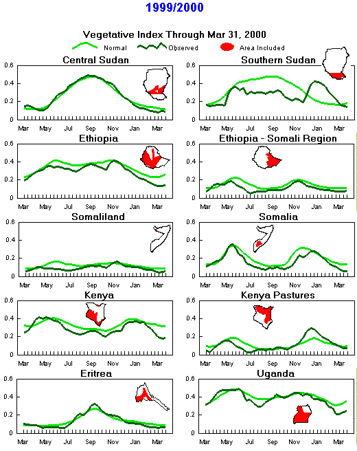
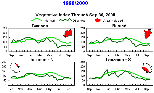
Seasonal Vegetation Index
(Note differences in months due to timing of seasons)
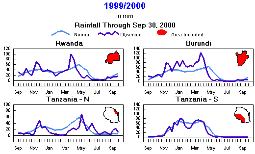
Seasonal Rainfall
(Note differences in months due to timing of seasons)

Current season
|
Back to historical analysis page
Preliminary Monthly Weather Analysis
Eastern Africa and the Horn
From the African Desk, Climate Prediction Center, NOAA
Note: This information should be used with caution.
Weather data based on preliminary reports.
-
September 2000 - Rainfall for the month was generally below normal, with little or no rain in Tanzania, southeastern Ethiopia, interior Kenya and Somalia. Northern crop and pasture areas in Sudan continued to see below-normal rains and above-normal temperatures, with satellite estimates suggesting the driest crop area was in west-central Sudan, including eastern Darfur and western Kordofan. Satellite estimates of both rainfall and vegetation health also suggest some dryness in southern Sudan near western Jonglei. Moderate rains (100-150 mm) fell in southwestern Sudan, central Uganda, and western Kenya. Isolated heavy rains (106-170 mm, 127-475% of normal) fell in north-coastal Tanzania and offered some local drought relief in northeastern Kenya. Satellite estimates indicated below-normal rains for Ethiopia, with 50 to 150 mm in the west and under 50 mm elsewhere. The early end to the main rainy season appears to have occurred in central areas where the season began late, including Wello, Tigray and Shewa, resulting in a shortened rainy season. This is the same area where the minor season rains failed during February to May. Temperatures averaged 2 degrees C above normal in central Sudan but near normal elsewhere. >
- September 21-30 2000 - The long-term rainfall deficits continued in Tanzania, Kenya, and southern parts of Ethiopia and Somalia. Amounts in this region ranged from light to moderate (1-72 mm, 2-384% of normal) in central and southern Sudan, northwestern Somalia, Uganda and western Kenya. Satellite estimation of precipitation indicated 25 to 50 mm in western Ethiopia and mainly 1 to 10 mm in northern and central areas of Ethiopia, where the main rainy season appears to have ended early. No rain fell in northern and eastern Kenya. The largest long-term rainfall deficits exist in northern Kenya, where 12-month cumulative rainfall is as low as 25% of normal. Temperatures averaged near normal everywhere except 2 to 3 degrees C above normal in northern and central Sudan and 2 to 3 degrees C below normal in southern Sudan.
-
September 11-20 2000 - The ITCZ extended farther to the east to trigger light to moderate rains (5-50 mm) across much of southern Kenya and Uganda. Light to moderate rains (2-54 mm; 23-129% of normal) were also observed over much of central Sudan, while seasonably dry conditions prevailed across much of Tanzania. Satellite rainfall estimates indicated dry conditions over much of Ethiopia and Somalia. Temperatures averaged near normal everywhere, except 2 to 3 degrees C above normal in central Sudan.
-
September 1-10 2000 - Long-term rainfall deficits persisted in Kenya, northern Tanzania, and southern Ethiopia and extreme western Somalia. The rains in this region ranged from light to moderate (1-96 mm, 1-360% of normal) over central and southern Sudan, northern Ethiopia, Uganda, and Kenya. Most of Somalia was seasonably dry. Isolated heavy rainfall (107 mm, 448% of normal) struck the northern coast of Tanzania.
Temperatures averaged near normal everywhere except 2 to 3 degrees C above normal in central Sudan, Kenya and central Tanzania. The seasons rainfall appears to be below normal in Northern Darfur and Northern Kordofan provinces in central and western Sudan.
-
August 2000 - The rains were a mixture of light to moderate, with 25 to 150 mm (25-75% of normal) in central Sudan, 50 to 150 mm (50-125% of normal) in southern Sudan and Uganda. Above-normal rains in western and central Kenya (50-180 mm, 110-215% of normal) eased long-term rainfall deficits, but amounts of 20 mm or less elsewhere in Kenya, northern Tanzania, and southern Ethiopia had little impact on the drought. Satellite rainfall estimates indicated more than 200 mm in northern Ethiopia and 100 to 200 mm in interior Eritrea. Temperatures were normal except for 2 to 3 degrees C above normal in central Sudan.
-
August 21-31 2000 - Severe long-term rainfall deficits continued in Kenya, northern Tanzania, and southern Ethiopia. Light to moderate rains (1-37 mm, 2-209% of normal) fell in southern Sudan, Uganda, western Kenya and extreme northwestern Tanzania. The reported rainfall in the sub-region was generally below normal, especially in Sudan, Ethiopia, and Uganda. Key agricultural areas across central Sudan measured mostly under 25 mm of rain, according to satellite data, and temperatures 3 to 5 degrees C above normal accompanied the dryness. Temperatures averaged near normal elsewhere.
-
August 11-20 2000 - Abundant rains (28-90 mm; 137-350% of normal) in the Lake Victoria region, northwestern Uganda and parts of central Kenya offered some relief from the long-term dryness. However, rainfall deficits prevailed along the coast of Kenya and seasonable dryness prevailed across southern and northern Kenya, and Tanzania. To the north, below-normal rains (8-71 mm; 3-36% of normal) fell over western Sudan, while moderate to heavy rains (36-136 mm; 63-217% of normal) hit eastern Sudan. Satellite rainfall estimates indicated heavy rains (100-200 mm) over northwestern Ethiopia, while Somalia remained seasonably dry. Temperatures were generally near average across Uganda, Kenya, and Tanzania. They averaged 2 to 3 degrees C above normal over much of Sudan.
-
August 1-10 2000 - Long-term rainfall deficits continued in interior Kenya and northern interior Tanzania, but unseasonably heavy showers (locally exceeding 50 mm) fell in west-central Kenya. Light to moderate rains (1-77 mm, 4-390% of normal) fell in coastal areas of Kenya, central and southern Sudan, extreme northwestern Somalia and Uganda. Satellite estimates of precipitation totaled 25 to 100 mm over central and northern Ethiopia and between 1 and 25 mm in Eritrea. Rainfall in central Sudan diminished from the prior period, with most crop areas measuring under 25 mm. Rainfall was spotty during the prior period, so some locations are likely becoming quite dry. Temperatures averaged 2 to 4 degrees C above normal in northeastern Sudan, northwestern Kenya and inland Tanzania, but 2 to 3 degrees C below normal in western Kenya and Uganda.
-
July 2000 - Light to moderate rains (1-150 mm, 17-127% of normal) fell in central Sudan, Uganda, coastal and western Kenya, and the northeastern coast of Tanzania. Isolated heavy rains (207 mm, 151% of normal) fell in central Sudan. Satellite estimates indicated abundant seasonal rains across central, northern and western Ethiopia. Light rainfall over northern and eastern interior Kenya had no impact on severe long-term rainfall deficits, and no relief is expected until the seasonal rains begin in October. The drought areas of northern interior Tanzania remained dry. Somalia and eastern Ethiopia recorded seasonably dry weather. Temperatures were normal except in central and northern Sudan, where readings averaged 2 degrees C above normal.
-
July 21-31 2000 - Seasonably dry weather continued in northern Sudan, Somalia, extreme eastern Kenya and Tanzania. Satellite estimates of precipitation indicated that northern, western, and central Ethiopia picked up between 50 and 150 mm while Eritreas rainfall ranged from 0 mm at the coast to near 100 mm in the southwest. Light to moderate rains (1-65 mm; 4-368% of normal) fell in central and southern Sudan, Uganda, western Kenya and northwestern and coastal Tanzania. Long-term rainfall deficits continued over interior Tanzania and Kenya as well as southern Ethiopia and parts of northern Ethiopia. Marsabit, in northern Kenya, has reported less than one-fourth normal rainfall both in the past 3 months and the past 12 months. Temperatures averaged 2 degrees C below normal in northwestern Somalia but 2 to 4 degrees C above normal in central and northern Sudan and isolated places in northern and southern Tanzania.
-
July 11-20 2000 - Seasonably dry weather continued in northern Sudan, Somalia, eastern Kenya and Tanzania. Satellite estimates of precipitation indicated that northern, western, and central Ethiopia picked up between 50 and 150 mm while most of Eritrea recorded less than 2 mm. Light to moderate rains (1-70 mm; 20-189% of normal) fell in central Sudan, Uganda and west central Kenya. Long-term drought continued over interior Kenya, northern Tanzania, and southern Ethiopia. Temperatures were generally near normal except for isolated 3 degrees C above normal in northeastern Sudan.
-
July 1-10 2000 - Seasonably dry weather continued in northern Sudan, southern Ethiopia, Somalia, eastern Kenya and Tanzania. Satellite estimates of precipitation indicated that northern, western, and central Ethiopia picked up 10 to 100 mm. These were the heaviest rains for north-central areas since early May, and likely signal the delayed start of the main season rains. Moderate to heavy rains (10-117 mm; 18-282% of normal) fell in southern Sudan and west-central Kenya. Rains were light (1-6 mm; 30-347% of normal) in southeast Kenya. Little rain fell in drought-affected areas of Tanzania and northern and interior eastern Kenya. Temperatures were generally normal except 2 to 3 degrees C above normal in central Sudan.
-
June 11-20 2000 - Dry weather continued over central and eastern Ethiopia, Somalia and northern Sudan. June rainfall is normally light in much of Ethiopia, but satellite estimates indicate that little rain has fallen since May 1-10 in central and northern areas from Tigray to Shewa, areas that typically see some rain from May into June. Rains usually continue into June over Somalias central and southern coastal areas, but little rain has fallen this month south of Somaliland, according to satellite estimates. Dryness persisted in northern Kenya and much of Tanzania. Light to moderate rains (5-35 mm; 21-138% of normal) fell over southern Kenya, northern Tanzania and Uganda. Satellite data and surface measurements indicated moderate to heavy rains (up to 111 mm; 512% of normal) over the coast of Kenya and Tanzania. Severe drought continued over interior Kenya and southward through northern Tanzania while drought persisted in northern Ethiopia. Satellite estimates have depicted little rain over southern Sudan so far this month, especially over Jonglei. Temperatures were generally close to normal over the region.
-
June 1-10 2000 - Drought persisted over interior parts of Kenya and Tanzania, as well as southern Ethiopia. Seasonably dry weather covered Somalia and northern Sudan. Light to moderate rain (4-38 mm; 9-96% of normal) fell in Uganda and western Kenya while moderate to heavy rain (20-125 mm; 50-300% of normal) fell over coastal Kenya and Tanzania as well as western Ethiopia. Up to 10 mm (156% of normal) dampened northern Kenya, an area that has reported little rain this year. Satellite data indicated moderate rains in southern Sudan and northern Uganda and seasonably dry weather in central and southern Somalia. Most of the eastern two-thirds of Ethiopia has seen little rain since May 11. A break between the first (belg) season and main season rains is not unusual in late May and early June, but the current dryness follows a drought that covered much of the country from February to April. Temperatures were generally close to normal except 2 to 3 degrees C above normal in central Sudan.
-
May 2000 - Kenyas drought worsened, as little or no rain (0-25 mm; 0-50% of normal) fell in the pastoral northern areas, and only light rains (20-40 mm; 10-50% of normal) fell over interior central and southern areas. Normal rainfall was confined to locations near Lake Victoria and the east coast. The area with less than 50% of normal monthly rainfall extended southward into much of Tanzania as well as parts of Rwanda and Burundi. The dryness also included extreme southern Ethiopia and southwestern Somalia. May rainfall eased drought over most of Ethiopia, where satellite estimates showed above normal and heavy rains in the west and southeast (150-300 mm). Heavy to very heavy rains (150-300 mm) also inundated central Somalia. Moderate rain (50-150 mm; 45-250% of normal) fell over southern Sudan, northern Uganda, southern and northern Somalia, coastal Kenya and northeast Tanzania. Persistent drought continued over Kenya and southward into northern Tanzania and into parts of central Tanzania. Satellite estimates of cumulative rainfall from February to May indicated large deficits (100-300 mm) over the southern half of Ethiopia, interior Kenya, northern Tanzania, and southern Somalia. Estimated deficits exceeded 100 mm in north-central Ethiopia, Rwanda, central and northern Uganda, and southern Sudan.
-
May 21-31 2000 - Severe drought continued in Kenya, adjacent parts of southern Ethiopia, and northern Tanzania, as little rain fell. Light to moderate rain (13-37 mm) fell over western Kenya, mainly near Lake Victoria, while Meteosat data indicated moderate rain (25-100 mm) in western Ethiopia and southwestern Sudan. Rainfall amounts were negligible in eastern Ethiopia, Somalia and northern Sudan. Light to moderate seasonable rains fell in Uganda, Rwanda and Burundi. Temperatures were generally near normal.
-
May 11-20 2000 - Light to moderate rain (2-88 mm; 2-200% of normal) fell over central and south Sudan, Rwanda, Uganda and southern Kenya. Meteosat estimates indicated light to moderate rain (10- 100 mm) over the coastal areas of Somalia, the southeast coast of Kenya and the northeast coast of Tanzania, while moderate to heavy rain (25-150 mm) fell over southwest Ethiopia and northward along the border with Sudan. Little rain fell elsewhere in Ethiopia, which may be experiencing the seasonal break that often follows the first season rains. Burundi, Tanzania and interior Kenya remained unseasonably dry. Severe drought continued over most of Kenya, northern Tanzania, and extreme southern portions of Ethiopia and Somalia. Temperatures were generally near normal except for 3 degrees C above normal over northeastern Sudan.
-
May 1-10 2000 - Meteosat or surface reports indicated moderate to heavy rains (50-150 mm; 10-285% of normal) over southern Sudan, central and southern Ethiopia, and most of Somalia and Uganda. Meteosat estimates indicated very heavy rains of 200 mm or more over interior southern Somalia near the Hiran and Bakool regions, including the Shebelle River valley. The rains have reportedly caused flooding in Somalia. Heavy rains of 200 to over 300 mm also struck the east coast of Kenya and the northeast coast of Tanzania. In contrast, Burundi and Rwanda were unseasonably dry, and severe drought intensified over interior Kenya southward into the interior of the northern Tanzania. Rainfall totaled 10 mm or less in the drought area. Temperatures in East Africa were generally within 2 degrees C of normal.
-
April 2000 - The rainfall trend improved noticeably in Ethiopia and Somalia, with Meteosat estimates indicating fairly large totals (100-150 mm) over most parts of both countries. Interior Kenya continued to have little rain (5-121 mm; 4-103% of normal). Light to moderate rain (11-150 mm; 13-351% of normal) fell over Tanzania, eastern Kenya, southern Sudan, Burundi and Rwanda. During the period in review, satellite estimates of April rainfall compared with the normal indicated above normal over Somalia, central and northern Ethiopia and Uganda; normal over south Sudan and below normal over Tanzania, Burundi, Rwanda and eastern Kenya. Based on estimated seasonal rainfall totals, drought persists from central Ethiopia southward through Kenya into Tanzania, with severe drought over southern and southeastern areas of Ethiopia and the northern half of Kenya. In the area of severe drought, rainfall since February 1 has totaled under 50 mm, with some areas collecting under 25 mm. Normal rainfall ranges from 100 to 250 mm, resulting in estimated cumulative rainfall as little as 10% of normal in the worst-hit locations.
-
April 21-30 2000 - Meteosat estimates indicated light to moderate rains (10-100 mm) over Ethiopia and moderate to heavy rains (50-150 mm) over most of Somalia. However, dryness persisted over extreme southern Somalia near the Kenya border. Light to moderate rains (2-99 mm; 4-327% of normal) fell over Uganda, Rwanda, Burundi, western Kenya, central southern Sudan and eastern Tanzania. Despite the improved rainfall in Ethiopia and Somalia, little rain fell in interior Kenya and Tanzania. As a result, drought worsened in most of Kenya and northern and western Tanzania. Temperatures in this region were near normal except for up to 3 degrees C above normal near the western border of Sudan.
-
April 11-20 2000 - Light to moderate rains (0-37 mm; 1-68% of normal) fell over Uganda, southeastern Tanzania, western parts of Rwanda and Burundi, and southwestern Kenya. Moderate to heavy rains (25-150 mm; 100-424% of normal) fell over southwestern Sudan. Meteosat estimates indicated moderate to heavy rains (50-150 mm) over central Ethiopia, patchy light to moderate rains (2-50 mm) in southern Somalia, and moderate rains (50-100 mm) in northern Somalia (Somaliland). Despite the recent improvement in rainfall, drought continued across southeastern and central Ethiopia, as well as in southern Somalia. Drought is worsening across much of Kenya and Tanzania. Kenyas rains have been normal only in the far west and parts of the southeast coast. Drought conditions are especially serious in north-central Kenya, where annual rainfall has been as little as one-third of normal and 90-day totals have been less than 10% of normal. Temperatures in the region were near normal except 3 to 4 degrees C above normal over northeast and central Sudan.
-
April 1-10 2000 - Light to moderate rains (0-20 mm; 0-20% of normal) fell in Sudan, Ethiopia, Somalia and northern Kenya. This is an indication that the ongoing dry pattern over these areas persists. In Ethiopia, one of the driest belg rainy seasons on record continued. Activity did, however, pick up in parts of Ethiopia, as moderate rains (25-50+ mm) extended from Gojam northward to western Eritrea. Showers also dropped up to 50 mm in the southwest. Extremely dry conditions persisted from eastern Tigray southward through Shewa and eastward through the Somali region. According to satellite estimates, extreme dryness also extended westward from the Addis area into East Welega. Little or no rain has fallen in these regions so far this season. Since the belg rains typically start in February and end by late May, this growing season appears to be largely a failure. Satellite imagery depicted increased rainfall after April 10, so some improvement is expected. Elsewhere, the main rainy season appeared to have started in Somalia, which has experienced long-term dryness. The season typically begins in early April, so the rains have not been especially late. However, the rains were mainly limited to the far south, from Mogadishu to Kenya. The northward movement of the ITCZ has been rather slow and its associated rainfall weak. Light to moderate rains with isolated heavy rains (5-381 mm; 5-581% of normal) fell in Burundi, Rwanda, southern Uganda, and south and central Tanzania. Satellite estimates displayed light to moderate rainfall (10-100 mm) over western Ethiopia, Uganda, Burundi, Rwanda, Tanzania, southern Kenya and the southern tip of Somalia. Over the past 1 to 2 months, abnormal dryness has extended from Ethiopia and northern Kenya westward through northern Uganda, southern Sudan, and into the Central African Republic (CAR). Abundant showers (50-100 mm) hit northern Uganda this period, according to satellite estimates, easing the dryness. Temperatures in East Africa were generally within 2 degrees C of normal except up to 3 degrees C above normal over northern Sudan.
-
March 2000 - Rainfall was near record-low levels in Ethiopia and interior Kenya, with satellite estimates indicating negligible totals for most of Ethiopias Somali region (4 to 30 mm below normal) and no more than light amounts (less than 20 mm) over northern areas, including most of the belg crop areas. Highest amounts were confined to the southwest, where up to 100 mm fell. Negligible rains also fell in northeast Uganda, southern Sudan, and northern pastoral areas of Kenya (6 to 35 mm below normal). Satellite estimates indicate moderate to heavy rains (200 to 300 mm or more) fell over Burundi, Rwanda, and western and southern parts of Tanzania, while light to moderate rains (22-82 mm; 23-92% of normal) fell over southeast Uganda. Satellite estimates indicate that small pockets of east-coastal and west-coastal Kenya picked up over 100 mm. Somalia was mostly dry, but amounts are typically light during March.
-
March 21-31 2000 - Light rains (0-13 mm; 0-70% of normal) fell from northern Uganda and interior Kenya northward through southern Sudan and most of Ethiopia and Eritrea. These amounts were 10 to 50 mm below normal and represent a continuation of the dry pattern that has persisted since February, when Ethiopias belg rains typically start. In contrast, up to 182 mm of rain (417% of normal) pounded Rwanda, with satellite data depicting the wettest area in the south near the Burundi border. Moderate rains (7-90 mm; 2-911% of normal) fell over Tanzania and southeast Kenya. Also, light to moderate rains (1-18 mm; 2-71% of normal) fell over central and southern Uganda, western Kenya, and isolated parts of Somalia. The seasonal rains in Somalia normally begin around the first week of April, so the season has not been abnormally late so far. Meteosat estimates indicated moderate to heavy rainfall (50-150 mm) over Burundi and eastern and southern Tanzania. Temperatures were near normal.
-
March 11-20 2000 - The rainy season is off to a late start. Rainfall was quite variable with isolated moderate to heavy rains (32-84 mm; 112-268% of normal) over southern Uganda, southern Kenya, and central Tanzania. Light rains to dry conditions, however, prevailed over northern Uganda, northern Kenya, Ethiopia, and Sudan. Satellite rainfall estimates also indicated dry conditions over Somalia and light to moderate rains (5-100 mm) over Tanzania. Temperatures were near normal.
-
March 1-10 2000 - Light to moderate rains (2-47 mm; 3-125% of normal) fell over Tanzania, southern Uganda and southwestern Kenya, while Ethiopia and Somalia remained dry except for isolated light rains over the Ethiopian highlands. Ethiopias belg rains, which normally start around February, have yet to materialize. Satellite rainfall estimates indicated light to moderate rains (10-100 mm) over Burundi and Rwanda, while dry conditions prevailed over Somalia. Temperatures over the region were near normal except for pockets of below normal (3 degrees C) over central Sudan, Lake Victoria, and parts of eastern Tanzania.
-
February 11-20 2000 - The southern part of the region continued to be atypically dry for two periods in a row, with most stations reporting no rainfall. Light to moderate rains (5-40 mm; 12-65% of normal) were confined to western, central, and southern Tanzania. Sudan, Ethiopia, and Somalia continued to be seasonably dry. Ethiopias belg rains, which normally start around February, have yet to materialize. Temperatures were near to below normal across the region except in the northern part of Sudan, where they averaged 2 to 4 degrees C above normal.
-
February 1-10 2000 - The region was unseasonably dry with only light to moderate rains confined to the central and southwestern areas of Tanzania as well as the Lake Victoria basin. Reported temperatures over the region were mainly near normal.
-
January 2000 - Light rains (5-10 mm; 10-80% of normal) were reported over Rwanda, Uganda, Kenya, and northern Tanzania. Seasonably dry conditions prevailed over Sudan, Ethiopia, and Somalia.
-
January 21-31 2000 - Light rains (5-10 mm; 5-80% of normal) fell over northern Tanzania, Kenya, Uganda, and Rwanda, while dry conditions prevailed over Ethiopia and Sudan. Satellite rainfall estimates also indicated dry conditions over Somalia. Temperatures were generally near average to 1 to 2 degrees C below normal across the region. They were 2 degrees C above normal across the northern half of Sudan.
-
January 11-20 2000 - Satellite rainfall estimates indicated moderate to heavy rains (50-200 mm) in western and southern Tanzania, as well as Rwanda and Burundi. Moderate rains (19-69 mm, 100-399% of normal) fell over the Lake Victoria basin; the remaining areas of the region were mainly dry. Pockets of below-normal temperatures (up to 3 degrees C) were reported over western parts of the Ethiopian highlands and west-central Uganda, while above-normal temperatures were reported over east-central and northwestern Sudan.
-
January 1-10 2000 - Satellite rainfall estimates indicated moderate to heavy rains (50-150mm) over central western Tanzania and moderate rains (25-100mm) over southern, central and northeastern Tanzania extending to Rwanda, Burundi and the Lake Victoria basin. Light to moderate rains (10-100mm) were received over the Ethiopian northern highlands, otherwise the remaining areas of the region were mainly dry. Normal temperatures were reported except over the Lake Victoria region where low temperatures (4-5 degrees C below normal) were reported.
-
December 1999 - Satellite rainfall estimates indicated moderate to heavy rains (150-300 mm) over western Tanzania, easing earlier dryness. Rainfall reports indicated moderate to heavy rains (80-218 mm, 93-205% of normal) over southern and central Kenya and light to moderate rains (40-91 mm) over most parts of Uganda and Rwanda. Totals remained below normal (20-70% of normal) in northern Kenya. Light rains fell over western and southern Ethiopia.
-
December 21-31 1999 - Rainfall reports and satellite rainfall estimates indicated moderate rains (10-52 mm, 140-245% of normal) southeastern Kenya, Burundi, Rwanda, and western and southeastern Tanzania. Dry conditions prevailed over central and northern Tanzania. Seasonable dry weather continued over Sudan, Ethiopia, and Somalia. However, temperatures were up to 5 degrees C above normal over northern Sudan and 3 degrees below normal over central Ethiopia.
-
December 11-20 1999 - Satellite rainfall estimates indicated moderate to heavy rains (50-150 mm) over all but northern Tanzania, alleviating dryness caused by a delayed rainy season. Elsewhere, close-to-normal rains fell. Temperatures were mostly near normal except for pockets in central and western Ethiopia where reported readings ranged up to 5 degrees C below normal.
-
December 1-10 1999 - Rainfall reports indicated heavy rains (53-88 mm; 195-242% of normal) over central and western Kenya and moderate rains of about 30 mm (201% of normal) over northwestern Uganda. The recent rains have nearly eliminated moisture deficits in pastoral areas of Kenya, though more rain would be welcomed. Satellite rainfall estimates indicated a pocket of heavy rain (100-150 mm) over southern Somalia, where the season started out abnormally dry and is ending abnormally wet. Light to moderate rains (10-47 mm) fell over western Ethiopia. Abnormal dryness continued over central and southern Tanzania. However, temperatures over the sub-region were near normal.
-
November 1999 - Rainfall was generally below normal over northern (Ethiopia) and southern (southern Tanzania) parts of eastern Africa and above normal in the middle (southern Somalia, Kenya, southern Uganda, northwest Tanzania). Dryness persisted over southern Tanzania, which measured little or no rain for the month. Long-term deficits remained over northern Kenya, which recorded 25 to 65% of normal rainfall. Satellite estimates indicated little rain over northeastern Uganda and below-normal rains over the northwest. October, however, was wet in the northwest. Heavy rains improved the short rainy season near the Lake Victoria region, central Kenya, south Uganda, and western Tanzania, with satellite rainfall estimates over 300 mm. Monthly amounts over Kenya ranged up to 522 mm. Satellite estimates indicated that up to 200 mm of rain hit extreme southern Somalia.
-
November 21-30 1999 - Satellite rainfall estimates indicated moderate rains (50-100 mm) over northern Tanzania, and heavy rains (100-200 mm) over western Kenya, southern Somalia, western Tanzania, and Lake Victoria. This was the second consecutive 10-day period with above-normal rains for most of this region. Over central Kenya, reported rainfall totaled 100 to 235 mm (201-333% of normal), but amounts were less (4-25 mm) in the pastoral northern areas, where short-season amounts remained below normal. Abnormal dryness continued over southern Ethiopia (0-25 mm), where monthly rainfall was well below normal, and southern Tanzania, where satellite rainfall estimates showed less than 2 mm, and the long-rains season has been poor so far. Temperatures were not homogeneous, with temperatures up to 5 degrees C above normal over Sudan and 3 to 4 degrees C below normal over Ethiopia, Uganda, and northern Tanzania.
-
November 11-20 1999 - Heavy rains soaked Uganda (up to 117 mm; 192% of normal) and central Kenya (169-249 mm; 252-349% of normal). Moderate rains (25-100 mm) fell over remaining areas of Kenya except in the northwest. Elsewhere, abnormal dryness prevailed over Sudan, Ethiopia, Somalia, and southern Tanzania. Temperatures were near normal over the region, except 4 degrees C below normal over northern Tanzania and northern Ethiopia.
-
November 1-10 1999 - Rainfall was below normal except over central Kenya (31-73 mm; 142-212% of normal), extreme northern Tanzania (40-45 mm; 129-131% of normal), southern Somalia (2-25 mm), and the east coast of Kenya (up to 17 mm), but near-drought conditions continued over northern and eastern Kenya and most of Tanzania, as the short rainy season has been deficient since October. Some dry pockets likely persist in Rwanda and Burundi, where estimated 10-day rainfall ranged from 10 to 50 mm. Near-normal to below-normal temperatures dominated the region.
-
October 1999 - Monthly amounts were more than twice normal over central and northern parts of both Sudan and Ethiopia. In contrast, rainfall was under 25% of normal over northern and eastern Kenya, signifying a slow start to the short rainy season. Satellite estimates indicated that the dryness extended northward into coastal areas of southern Somalia, possibly signifying an unfavorable short rains season. Moisture was near or above normal to the west from central Kenya into Uganda and southward to Rwanda, but rainfall was one-half of normal or less in Tanzania except for the Lake Victoria area. Some amounts in northern Uganda exceeded 300 mm while interior Tanzania measured 0 mm.
-
October 21-31 1999 - Rains diminished to more seasonal levels over Ethiopia, with light to moderate rains (10-50 mm) in southwest and southern Ethiopia and dry weather north, central, and east. Amounts also declined to more typical levels over Uganda, where showers deposited 30 to 100 mm. Rainfall was below normal again in Rwanda, with sparse ground reports and satellite estimates indicating 0 to 20 mm. Estimated rainfall was light (0-25 mm) in Burundi, but this followed heavier rains during the preceding period. The short rains improved over central Kenya, with variable amounts of 0 to 100 mm, but 4-week totals remained under 25% of normal at several stations in central and coastal Kenya. For the second consecutive year, the vuli (short season) rains have been below normal in Tanzania, though amounts were normal (15-30 mm) along the Lake Victoria coast during this 11-day period. Given the continued La Niña, there is a likelihood of below normal rains during the short rainy season (October-December) Tanzania and eastern Kenya this year. Satellite estimates suggested continued dryness over coastal southern Somalia, with increased rain inland toward Ethiopia. The minor deyr season rains appear to have been below normal over the lower Shebelle and Juba River valleys.
-
October 11-20 1999 - Heavy rains (83-162 mm; 109-600% of normal) persisted from central Ethiopia into eastern Sudan. Moderate to heavy rains (20-150 mm) continued over Uganda and extreme western Kenya. Four-week rainfall totals in Kenya have been twice normal near Lake Victoria, while amounts have been below normal in central and eastern Kenya. Rwandas rainfall diminished to mostly below normal, as Burundis totals remained light to moderate. Satellite estimates indicated little rainfall so far this month in southern Somalia, where October rainfall typically varies from 50 to 100 mm. Temperatures were mostly below normal over the region, with departures to minus 4 degrees C in Uganda.
-
October 1-10 1999 - Abnormal rains (67-126 mm; 143-560% of normal) extended from central Sudan to many parts of Ethiopia (33-207 mm; 153-699% of normal). The moisture helped to relieve dryness across the southern half of Ethiopia, where rainfall was below normal in August and September. Heavy rains of more than 100 mm hit northwestern Uganda and parts of the southwest and southeast, with 50 to 100 mm elsewhere. Uganda has been experiencing an unusually wet rainy season. Isolated above-normal rains fell elsewhere over the Victoria lake region, including western Kenya and eastern Rwanda. Below-normal temperatures (3 to 4 degrees C below normal) extended from Tanzania to Burundi, northern Uganda, and Ethiopia. Temperatures were 3 to 4 degrees C above normal in northern Sudan.
-
September 1999 - Satellite rainfall estimates showed monthly rainfalls over 300 mm along the border region between Sudan and Ethiopia. Elsewhere, monthly totals were below normal except over central Sudan and some isolated cases in northern Sudan, northern Ethiopia, western Kenya, and Rwanda. Near normal temperatures prevailed.
-
September 21-30 1999 - Satellite rainfall estimates showed heavy rains (100-200 mm) over the central border region of Ethiopia with Sudan. Elsewhere, rainfall was below normal except over central and northern Ethiopia and northern Sudan. There were isolated occurrences of above-normal rainfall in northern Sudan. Above-normal temperatures were observed over northern Sudan (2-3 degrees C above normal), while near-normal temperatures prevailed over most parts of the region.
-
September 11-20 1999 - Dry conditions prevailed across the region, except central Sudan and parts of central Ethiopia, where rainfall amounts totaled 30-90 mm (90-380% of normal). Unseasonable rains (15-40 mm; 95-170% of normal) were observed along the coast of Kenya, while lighter rains fell in southern Kenya. Satellite rainfall estimates indicated dry conditions over Somalia, while heavy rains (50-200 mm) were estimated over the northern part of Republic Democratic of Congo. Temperatures were generally 2 to 4 degrees C above normal in Sudan and below normal (3-5 degrees C ) were observed over much of Kenya, Uganda, Rwanda, Burundi, and Tanzania.
-
September 1-10 1999 - Dry conditions prevailed over much of the region. However, heavy rains (48-104 mm; 127-206% of normal) persisted over northern Ethiopia and extended into east-central Sudan. Rainfall over southwestern Ethiopia continued below normal (1-25 mm; 1-50% of normal). Four-week amounts totaled under 50% of normal there. The dryness extended into southeastern Sudan. Seasonably dry weather prevailed across southeastern Ethiopia and the pastoral areas of Kenya. A few showers dampened Somalias coast, while the interior was seasonably dry. Temperatures were near normal.
-
August 1999 - The rainfall pattern was mixed, with monthly rainfall below normal in southwest Ethiopia and above normal in central Sudan, northern Ethiopia and the border region between Sudan and Ethiopia. Amounts exceeded 300 mm in northern Ethiopia and 100 mm in central Sudan. Somalias totals were generally above normal due to anomalous showers in early August. Monthly temperatures were near normal, except 2-3 degrees C below normal over western Tanzania.
-
August 21-31 1999 - Heavy downpours (112-153 mm; 139-296% of normal) continued over northern Ethiopia and extended into east-central Sudan. Lighter rains fell south and north of this region, with below-normal rains in Sudans Blue and Upper Nile regions and southwestern Ethiopia. Rains were also below normal in southeastern parts of North Darfur and adjacent areas of Kordofan in central Sudan, but heavy rains fell across this region during the preceding period. Temperatures were near normal across the region.
-
August 11-20 1999 - Isolated heavy downpours (70-150 mm; 140-270 % of normal) soaked east-central Sudan eastward into northern Ethiopia. Lighter rains were observed across much of the region. Satellite rainfall estimates indicated seasonably dry conditions over Somalia, Tanzania, and the Lake Victoria basin. Temperatures were near normal across the region, except over western Tanzania, where readings were 2 to 5 degrees C below normal.
-
August 1-10 1999 - Isolated heavy rains (41-159 mm; 126-488% of normal) fell over central Sudan, while heavy showers overspread central Ethiopia (102-136 mm). Unseasonably heavy showers (35-105 mm; 400-800% of normal) fell near Lake Victoria in western Kenya and northern Tanzania. Temperatures were near normal except for isolated values in western Kenya and western Tanzania of 2 to 4 degrees C below normal.
-
July 1999 - The main rainy season started around early July in the areas of north-central Ethiopia that had experienced severe drought during the belg season. The current season has produced seasonably heavy rains across western and northern parts of the country. Southern and eastern areas were seasonably dry. Rainfall in Sudan was variable. Most of the main crop areas tallied 100 mm or more for the month, but the satellite estimates suggested that dry pockets developed, and somewhat higher-than-normal temperatures were consistent with below-normal rain in parts of central Sudan. In Kenyas crop areas near Lake Victoria, amounts were adequate, but surrounding areas were drier than normal. Rainfall was close to seasonal levels elsewhere in East Africa.
-
July 21-31 1999 - Seasonably heavy rains (50-200 mm; 70-110% of normal) fell over crop areas in Eritrea and Ethiopia, while heavy showers overspread Sudans crop areas (50-100 mm, isolated 150 mm). The remainder of East Africa was seasonably dry except for showers (25-50 mm) in western Kenya and western Uganda. Parts of Ethiopia, Uganda, and Kenya and southern Sudan remained below normal. Temperatures averaged 1 to 4 degrees C below normal in Tanzania and near normal elsewhere.
-
July 11-20 1999 - Heavy rains (50-105 mm; 135-350% of normal) fell in northern Ethiopia, adjacent southern Eritrea, and southern Sudan, while drier conditions prevailed over central Sudan and southwestern Ethiopia. Unseasonably heavy rains (50-100 mm; 115-280 % of normal) fell over most of Uganda and parts of extreme western Kenya, while seasonable dryness continued over extreme southwest Uganda, most of Kenya, and Tanzania, except for isolated wet spots on the coast. Meteosat rainfall estimates indicated seasonably dry conditions over Somalia, Rwanda, and Burundi. Temperatures were generally 1 to 2 degrees C below normal.
-
July 1-10 1999 - Heavy rains finally covered north central Ethiopia with amounts ranging from 45 to 195 mm (180-230% of normal). The rains, which likely marked the start of the rainy season in northern Ethiopia, extended to eastern and central Sudan, where spotty rains (10-60 mm; 70-150 % of normal) were observed. Seasonable dryness prevailed to the east part of Ethiopia into Somalia, though. Unseasonable rains (5-60 mm) fell over Kenya, while dryness prevailed over much of Uganda, Tanzania, Burundi, and Rwanda. Meteosat rainfall estimates indicated dry conditions over Somalia. Temperatures were generally 2 to 4 degrees C below normal across much of the region. They were 1 to 2 degrees C above normal over Sudan.
-
June 1999 - Below normal rains fell over parts of Kenya, southwestern Uganda, and much of Ethiopia. Abundant rains fell in southwestern Kenya, central Ethiopia, and southwestern Sudan. Temperatures averaged 1 to 4 degrees C below normal over Tanzania. Readings were near normal elsewhere, except over western Sudan, where they averaged 1 to 2 degrees C above normal.
-
June 21-30 1999 - Abundant rains (90-110 mm; 80-255% of normal) fell over southeast Sudan and central Ethiopia. In drought-afflicted areas in north-central Ethiopia (Wello and Shewa provinces), rainfall was abnormally light (0-10 mm; 0-50% of normal), indicating a slow start to the main rainy season. Eastern Ethiopia was seasonably dry. Drier conditions prevailed over Kenya, Uganda, Tanzania, and eastern Ethiopia. Meteosat rainfall estimates indicated dryness over Somalia, Eritrea, Rwanda, and Burundi, but little rainfall is expected during this time of the year in these countries. Temperatures averaged generally 1 to 3 degrees C below normal across Tanzania, Uganda, and southern Sudan. They were near to above normal over the northern half of Sudan, Ethiopia, and Kenya.
-
June 11-20 1999 - Rainfall was light (0-2 mm; 0-15% of normal) in north-central Ethiopia, where the earlier failure of the first rains caused drought. Rains typically increase around this time of year as the second rainy season gets underway. Heavier rains (30-100 mm) fell over western Ethiopia, but the south and east were seasonably dry. Parts of the south and east also recorded below-normal rains during the first season. Rainfall was minimal in Kenya, even in the west. Erratic rains this season have left some pastoral areas in the north and crop areas in the southwest with drought. Similarly, a poor rainy season affected Rwanda and southwest Uganda earlier. During June 11-20, rains were light over southwest Uganda and negligible over Rwanda. Somalia, which had a shortened rainy season, remained seasonably dry this period, but the rains in Sudan failed to progress northward, leaving central areas abnormally dry as well as parts of the south. Temperatures 2 to 3 degrees C above normal aggravated dryness in central Sudan. Readings were near normal elsewhere in East Africa.
-
June 1-10 1999 - Seasonably dry weather continued in drought-affected north-central Ethiopia, but moderate to heavy rains (10-50 mm) fell over western Ethiopia. Drier-than-normal weather continued in southern and eastern Ethiopia, Somalia, and the pastoral areas of Kenya, as well as Rwanda and southwestern Uganda. Estimated rainfall during the past 4 weeks has been under 50% of normal for most of this region. Satellite estimates again indicated dry weather for Somalia, where the rainy season was abnormally short. Satellite data indicated heavy showers over southern Sudan, especially in the southwest, with lighter rains in central Sudan. Temperatures over East Africa were near normal, except 1 to 3 degrees C above normal in central Sudan and 2 to 4 degrees C below normal in northern Tanzania.
-
May 1999 - The monthly highlight for May was the confirmed failure of the short season (belg) rains in north-central Ethiopia. The monthly rainfall was light to negligible (0-20 mm; 0-40% of normal) from Wello province southward through N. Shewa. As May is typically the last month of the belg rains, the season ended as badly as it began. Showers were heavy (200-300 mm or more; 100-150% of normal) in western Ethiopia, but rainfall was also below normal in the south and east, including the Ogaden region, where rainfall amounts ranged from 0 to 50 mm; (0-60% of normal). In addition, the rainy season ended early in Somalia, with little rain over most of the crop regions in southern and central Somalia after May 10. Monthly totals were mainly in the 20 to 50 mm range, compared with a normal of 20 to 100 mm. The rainy season also appeared to end early in Burundi, Rwanda, southwestern Uganda, and parts of Kenya, especially in northern pastoral areas and the south-central and southeastern areas of Kenya away from the oceans coast (0-50 mm; 0-30% of normal). Monthly totals in Burundi, Rwanda, and southwest Uganda were mostly under 25% of normal. Rainfall was normal to above normal in central and southwestern Sudan, with amounts exceeding 300 mm locally in southwestern Sudan, according to satellite estimates.
-
May 21-31 1999 - Heavy rain (50-130 mm) fell across the western third of Ethiopia, but the drought-affected area of north-central Ethiopia picked up little or no rain. Rainfall was abnormally light in southern and eastern Ethiopia, with amounts mostly under 10 mm except for isolated totals exceeding 30 mm. Eritrea, where the rainy season normally starts toward the end of June, was seasonably dry. The rainy season appears to have ended early in Somalia, where the southern half of the country recorded little or no rain. The main season rains started somewhat late, so the length of the season has been significantly shortened, essentially lasting from mid-April to early May. Rainfall was abnormally light (0-35 mm; 0-75% of normal) in southwestern Kenya and along the northern border with Ethiopia, a sign that the main rainy season may be ending early in Kenya. The season also ended early in Burundi and Rwanda, where little or no rain fell again. Seasonably heavy rains (25-100 mm) fell over Uganda and southwestern Sudan, according to satellite estimates. In contrast, rainfall was spotty in southwestern Sudan, where estimated amounts diminished from the previous period. Temperatures were generally near normal across the region, except 2 to 4 degrees C below normal in southwestern Sudan and 2 to 3 degrees C above normal in northern Sudan.
-
May 11-20 1999 - Little or no rain (0-12 mm) fell from Eritrea southward through central Ethiopia into Kenya, allowing the drought in north-central Ethiopia to continue unabated. The first (belg) rainy season has failed across Wello and Shewa provinces, and rainfall has been below normal over most of the remaining belg crop areas in Ethiopia. In addition, most of the Ogaden has been dry this month. Rainfall diminished across southern Somalia, where satellite estimates indicated 0 to 25 mm amounts. This contrasts with normal amounts of 20 to 30 mm. Northern Somalia (north of the sixth parallel) totaled above-normal amounts of 25 to 100 mm, except for lower amounts near the north coast. Except in the far eastern and western coastal areas, rainfall was abnormally light in Kenya (0-12 mm; 0-30% of normal). Rainfall in southern Kenya has totaled less than 50% of normal during the past 4 weeks. Little or no rain occurred over Rwanda, Burundi, western Tanzania, and southwestern Uganda. The rainy season ended early in this region. Ample rains (25-100 mm) fell over the rest of Uganda. Satellite estimates indicated widespread, heavy showers (50-150 mm) across southern Sudan from the 10th parallel southward. Temperatures were generally 1 to 2 degrees C below normal across East Africa.
-
May 1-10 1999 - Rainfall totaled only 0 to 10 mm over north-central Ethiopia, including Tigray, Wello, and Shewa provinces. This contrasts with normal rainfall of 10 to 25 mm. The first (belg) rainy season has been a virtual failure in this area, with near-normal rains only falling during parts of March. The rains in north-central Ethiopia often taper off toward late May, so the likelihood of consequential rainfall during this season is diminishing. Moderate to heavy showers (25-110 mm) fell over western parts of Ethiopia, while moderate rains (10-55 mm) fell in the south and extended into central Kenya as well as southern Somalia. Most of the main Kenyan crop areas again recorded seasonable showers, though dry pockets persisted, especially from Nairobi southward to the Tanzanian border. Heavy rain (50-110 mm; 100-150% of normal) covered eastern Tanzania, but most of the western half of the country remained dry. The rainy season appears to have ended somewhat early in western Tanzania, as the rains stopped in mid-April. Heavy showers (50-150 mm) stretched across southern Sudan and moved northward into east-central Sudans sorghum areas, where significant rainfall this early in the season is unusual. Satellite estimates indicated that heavy showers (50-150 mm) also fell over Uganda. Temperatures were generally 1 to 2 degrees C below normal across East Africa.
-
April 1999 - Worsening drought in central and northern Ethiopia highlighted the month, though late-month rains eased dryness elsewhere in Ethiopia. The entire belg rainy season has been poor in Ethiopia, especially in north-central areas (Shewa and Wello Provinces). April rainfall totaled less than 25% of normal in central and north-central Ethiopia and less than 50% of normal in the east. Late-month rains brought monthly totals up to 100% of normal in much of the west, but localized areas measured less than 50% of normal. Rainfall over the northern half of Kenya and adjacent southern Ethiopia totaled 50 to 60% of normal, so the season continued rather poor in the pastoral areas of Kenya. It was a mixed picture in the main crop areas of Kenya, as parts of the Rift Valley recorded under 50% of normal rainfall, while some stations farther west near Lake Victoria reported over 100% of normal and more than 200 mm. Satellite estimates suggest that April was abnormally dry in Rwanda and southwest Uganda. Rainfall was also likely below normal in Burundi and western Tanzania. Estimated amounts, however, exceeded 150 mm in eastern Tanzania and in the northwest near Lake Victoria.
-
April 21-30 1999 - Moderate to heavy showers (25-100 mm) covered the western, southern, and eastern third of Ethiopia. However, rainfall remained below normal (0-25 mm) in central and northern sections, continuing the drought that has prevailed since February. Somalia saw widespread showers this period, according to satellite imagery, with only the escaping the rains. Showers were also frequent across southern Sudan, with satellite-estimated rainfall of 50 to 150 mm in Equatoria, Jonglei, and southern parts of Lakes and Bahr El Ghazal. Dry weather encompassed western Tanzania, Rwanda, Burundi, southern Uganda, and parts of southwest Kenya. This was the second consecutive period that rainfall was below normal in western Tanzania and southwest Kenya. Satellite-estimated rainfall was above normal (50-150 mm) in northern Uganda, including the more-arid northeast region. Temperatures were generally 1 to 3 degrees C below normal in Tanzania, Uganda, and southwest Ethiopia, and near normal elsewhere.
-
April 11-20 1999 - Severe dryness continued across northern and western Ethiopia, with scattered showers providing little drought relief. Significant rainfall was limited to southwestern and south-central parts of the country, which measured 0 to 100 mm (0-145% of normal). The belg rainy season has been a virtual failure from the 10th parallel northward in Ethiopia as well as western Ethiopia north of the 8th parallel. This area collected mostly 10 mm or less during April 11-20 as well as April 1-10. Since February, the only period of seasonable rain occurred in early March. Conditions have also been dry in far eastern Ethiopia and Somalia north of the 5th parallel, but seasonable showers (25-100 mm) relieved dryness over southern Somalia this period. In Sudan, seasonable showers fell over the far south (Equatoria), but little rain has fallen so far this season in southern Sudan just north of Equatoria (Bahr El Ghazal, Lakes, Jonglei). Temperatures were generally above-normal (1-3 degrees C) in the dry areas of Sudan, Ethiopia, and Somalia, worsening the situation. In Kenya, rainfall was somewhat below normal, but 50 to 100 mm of rain relieved dryness in the northeast. Pockets of dryness occurred in the northwest and in the Rift Valley in west-central Kenya. Below-normal rains fell across interior Tanzania (0-25 mm; 0-60% of normal), with heavier rains (25-50 mm) near the coast. Season-to-date rainfall remains near to above normal in Tanzania due to heavy rains in March. Satellite rainfall estimates suggested that rains were seasonable in the Lakes region (Rwanda, Burundi, Uganda, Malawi, 0- 50 mm). Temperatures in this area averaged 1 to 3 degrees below normal.
-
April 1-10 1999 - Dryness further intensified across northern and
western Ethiopia, as significant rainfall was limited to the extreme southwest of the country. Amounts of 0 to 6 mm were under 25% of normal and represented a continuation of the dryness that has affected northern and many western sections since February. Dryness has been especially severe north of the 10th parallel this season, affecting Wello and Shewa provinces, but dryness has also affected the west down to the 8th parallel. Above-normal temperatures worsened dryness in northern Ethiopia, where readings averaged 2 to 4 degrees C above normal. Sparse rainfall reports indicated near to above-normal rains in extreme southern Sudan, suggesting the rainy season may have begun. In Somalia, only a few showers fell in the southwest, with the remainder of the country dry. As the main rainy usually starts in early April, it is now somewhat delayed. In Kenya, rainfall was generally above normal in the southwest, including most of the main maize region, but northern and eastern areas recorded less than 25% of normal rainfall. Four-week rainfall totals were below 25% of normal at some locations in the north and east, but over twice normal in the southwest. Above-normal rains also fell across Tanzania (25-90 mm; 50-280% of normal), continuing the wet pattern prevailing since February. Satellite rainfall estimates suggested that rains diminished over Rwanda and Burundi, with estimated amounts ranging from around 25 to 100 mm in Burundi and 10 to 30 mm in Rwanda. In Uganda, moderate to heavy rains (50-150 mm) covered central and northern parts, with lighter amounts (under 25 mm) in the southwest.
-
March 1999 - Parts of the region recorded substantial rains, particularly in eastern Tanzania, the western half of Kenya, and eastern Ethiopia, where rainfall amounts were 85-340% of normal. Drier conditions prevailed over the western part of Ethiopia, Rwanda, the eastern part of Kenya, central and western Tanzania, and Uganda. Satellite rainfall estimates indicated that dry conditions prevailed over Somalia, while southern Sudan estimated rainfall ranged between 20 and 50 mm.
-
March 21-31 1999 - Northern crop areas of Ethiopia remained dry until showers fell on March 27. Given that normal rains this season have been limited to the first 10 days of March, drought has developed north of the 10th parallel. Showers were more numerous in southern and central areas of the country, where rainfall totals were 120 to 180% of normal at some locations. However, rainfall was nearly non-existent across western Ethiopia, where most stations recorded little or no rain, resulting in near-drought conditions west of the 38th meridian. The extreme southern Sudan was also drier than normal, though showers in the south at the end of March gave hope that the rainy season was beginning. The rainy season typically starts around late March or early April in the south. Despite some promising showers in Somalia during mid-March, showers were sparse during the latter part of the month, indicating that the rainy season was not yet established. The season usually starts in early April across southern Somalia. Rainfall was below-normal over the eastern half of Kenya. In the western half , however, rainfall totals of 20 to 130 mm (70-220% of normal) kept moisture conditions intact. Heavy showers (60-220 mm; 200-270% of normal) pounded parts of central and southern Tanzania. Satellite rainfall estimates suggested that moderate rains (25-100 mm) fell over Uganda, Rwanda, and Burundi.
-
March 11-20 1999 - Rainfall (50-100 mm) was above normal south and east of Addis in Ethiopia, but below normal to the north, where amounts were negligible. Because February rainfall was below normal, this area, which includes Wello and North Shewa provinces, is vulnerable to drought if the rains do not improve shortly. In contrast, above-normal rains (5-100 mm) fell in southern Somalia and northern Kenya. If the rains represent the start of the rainy season in Somalia, they are early, as the rains typically start around the beginning of April. Amounts (25-60 mm) in western and central Kenya and northern Tanzania were seasonable, but rainfall has been unusually heavy since late February in western Tanzania and eastern DR Congo, where amounts this period ranged from 100 to 200 mm, according to satellite estimates. Widespread showers (50-100 mm) continued to increase moisture levels in Uganda, Rwanda, and Burundi. Satellite estimates indicated a few showers over southern Sudan, where the rainy season has not yet become established. Temperatures were generally 1 to 3 degrees C below normal across the region.
-
March 1-10 1999 - The belg rains (15-80 mm) began in central Ethiopia at the start of March, following abnormal dryness in February. Moderate rains (10-100 mm) appeared to mark the start of the main rainy season in central and western Kenya, helping to relieve drought. While little rain (0-10 mm) fell over northern and eastern areas, the minimal moisture was not unseasonable. Above-normal rains (100-200 mm) stretched from western Tanzania through DR Congo and northern Angola. The ample moisture extended northward through Burundi and into Rwanda (50-150 mm), relieving dryness in Rwanda. Widespread moderate (40-100 mm) rains also eased dryness in Uganda, though the extreme northeast remained rainless. Satellite estimates indicated a few showers over Somalia, where the rainy season usually starts in the first week of April, and southern Sudan, where widespread rains have started between mid-March and mid-April in recent years. Temperatures were generally near normal across the region, though 2 to 4 degrees C below normal in Uganda. After months of above-normal temperatures, readings in central and northern Sudan averaged close to normal.
Back to top
|
Current season
|
Back to historical analysis page
|